
NEW ORLEANS — Now downgraded as a depression after initially forming as a tropical storm in the Gulf of Mexico on Tuesday, an upgraded Hurricane Francine made landfall in southeast Louisiana on Wednesday night.
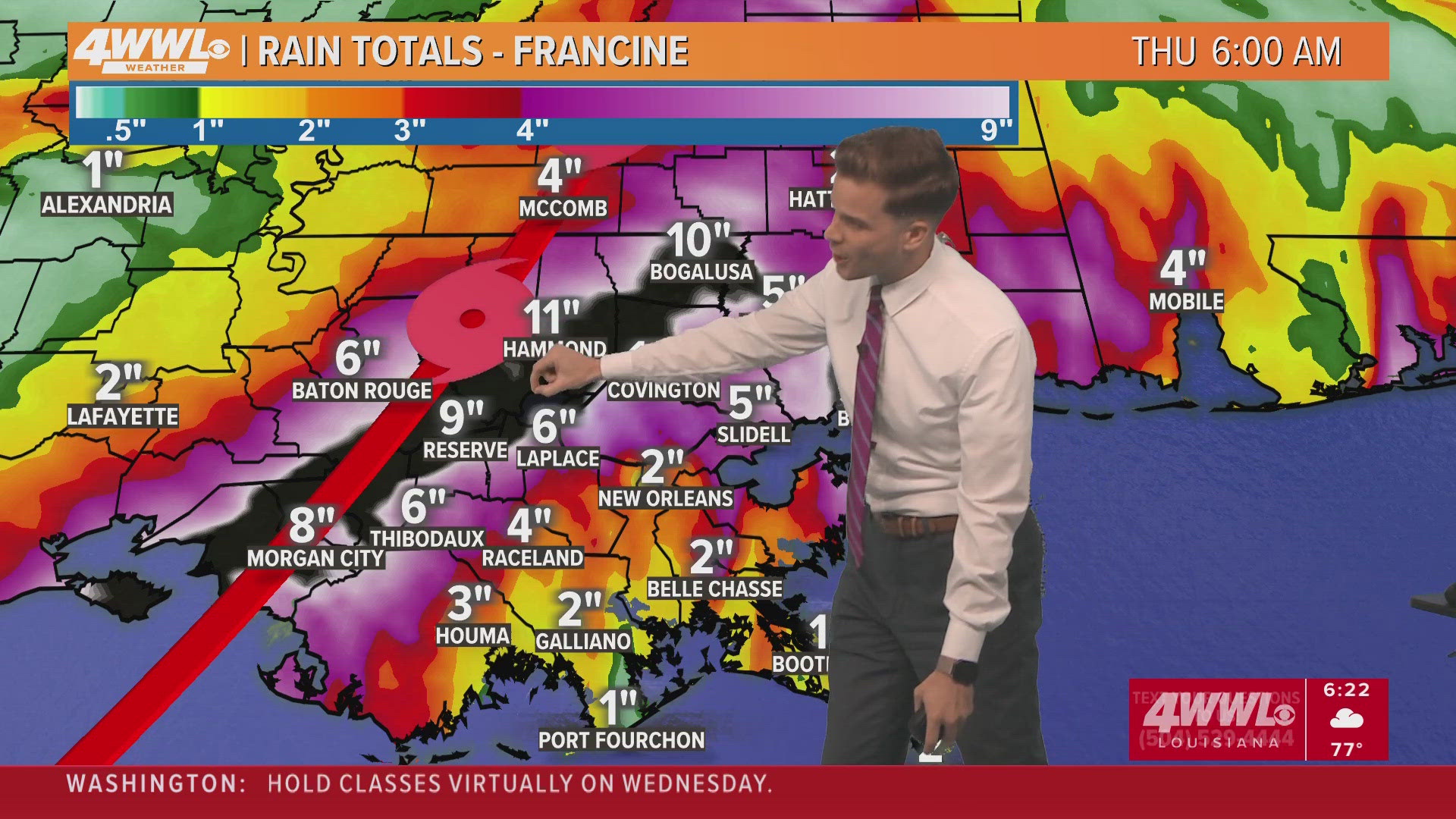
The storm dropped massive amounts of rain throughout the area and caused widespread power outages due to damaging wind gusts of 90 mph and more.
See complete details in the running live blog below:
Thursday 9:33 PM - Coast Guard reopens ports and waterways following Hurricane Francine
The Coast Guard Captain of the Port (COTP) New Orleans has set port condition normal as of 6 p.m., Thursday, following waterway assessments and coordination with federal, state, and local partners, a release said.
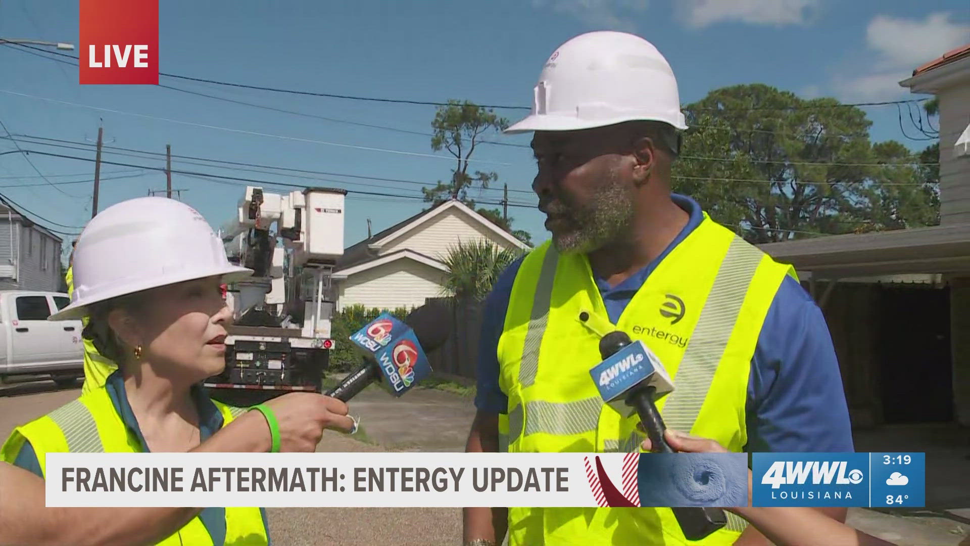
Thursday 9:05 PM - Entergy Louisiana gives update on power restoration times
According to Entergy, more than 50 percent of customers' power have been safely restored, with 150,000 restored.
- Entergy New Orleans estimates 75% of New Orleans customers will be restored on Friday, less than 48 hours after impact.
- 90% of affected customers in New Orleans are anticipated to be back online by Saturday, Sept. 14th - three days after impact.
Thursday 8:35 PM - Cleco says power has been restored to 83 percent of its customers
According to Cleco, 6332 customers remain without power.
Cleco's full statement:
“Our crews have made tremendous progress during our first day of restoration efforts, and crews are continuing to work into the night,” said Clint Robichaux, director of distribution operations and reliability.
The company’s restoration efforts include clearing trees from powerlines, replacing broken poles, repairing transformers and replacing downed wire.
“Our crews are still working to tackle the damage left behind by Hurricane Francine and get the lights back on for our customers. And while our crews are continuing to work, we do expect that some outages will last overnight,” said Robichaux. “We thank our customers for their support and patience.”
Thursday 7:47 PM - RTA provides updates on bus, streetcar, and ferry service
- RTA returned to full bus service over the course of the day after starting the morning with service on a limited schedule while also supporting the streetcar lines.
- The Canal-Cemeteries, Canal-City Park/Muse, UPT-Riverfront, and Rampart-Loyola streetcar lines are back in service. The St. Charles Streetcar Line remains out of service until further notice.
- Ferry service remains suspended until further notice.
- We are continuing to restore our Customer Service Center operations. With RTA land line phones down, we are operating Rideline and Paratransit at a reduced capacity and ask callers to be patient and keep trying.
Thursday 6:30PM - New Orleans City Hall to reopen and resume normal operations on Friday, Sept. 13 at 8 a.m.
Thursday 3 PM – Entergy New Orleans update on power restoration
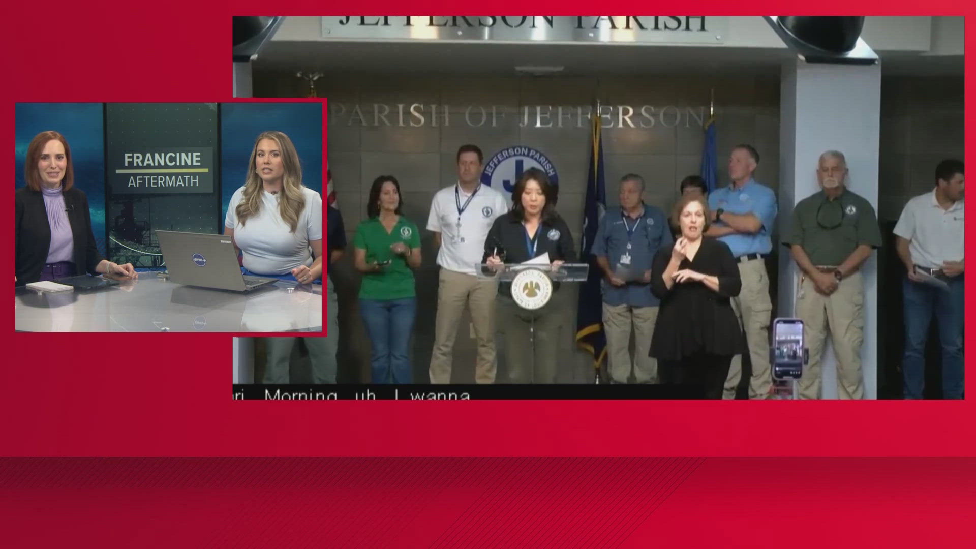
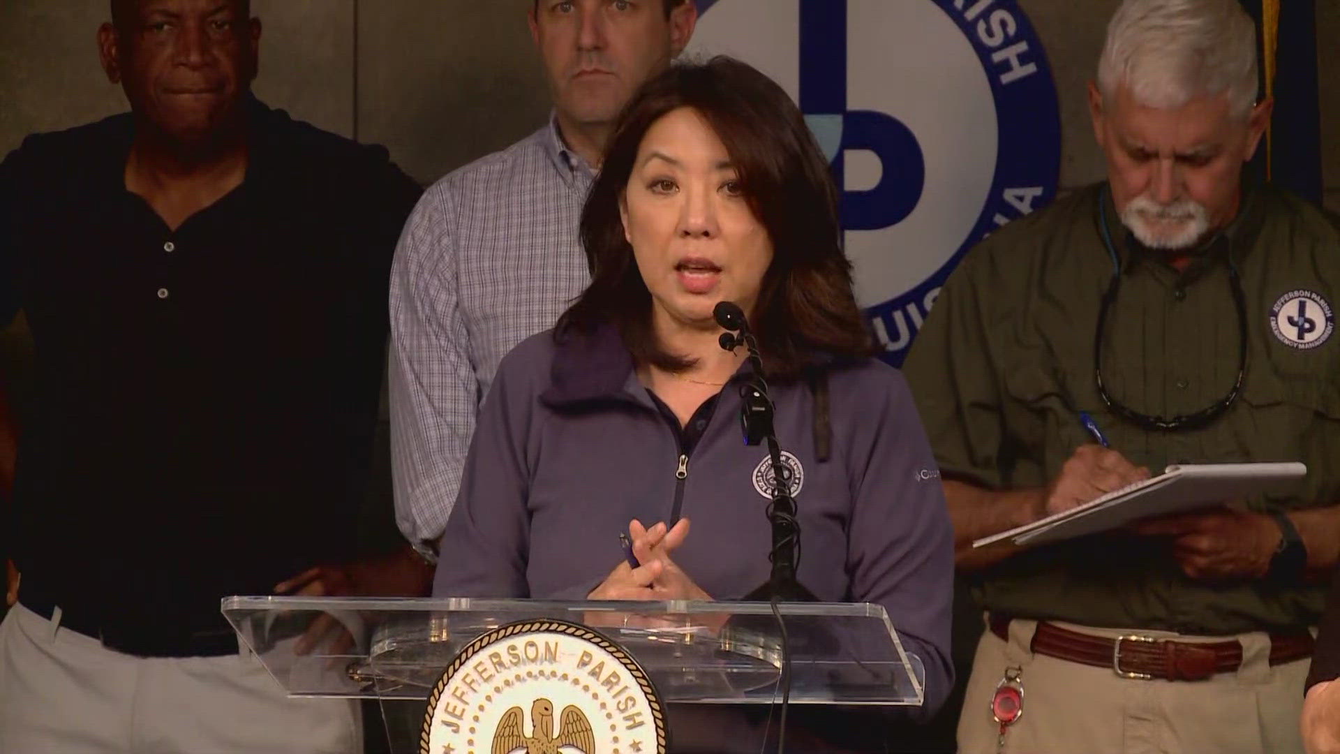
Thursday 2 PM – Jefferson Parish provides an update on Francine recovery
Thursday 1PM – Sewerage & Water Board requests continued water conservation
The SWBNO asked residents and businesses to continue to conserve water at this time to prevent sewerage backup.
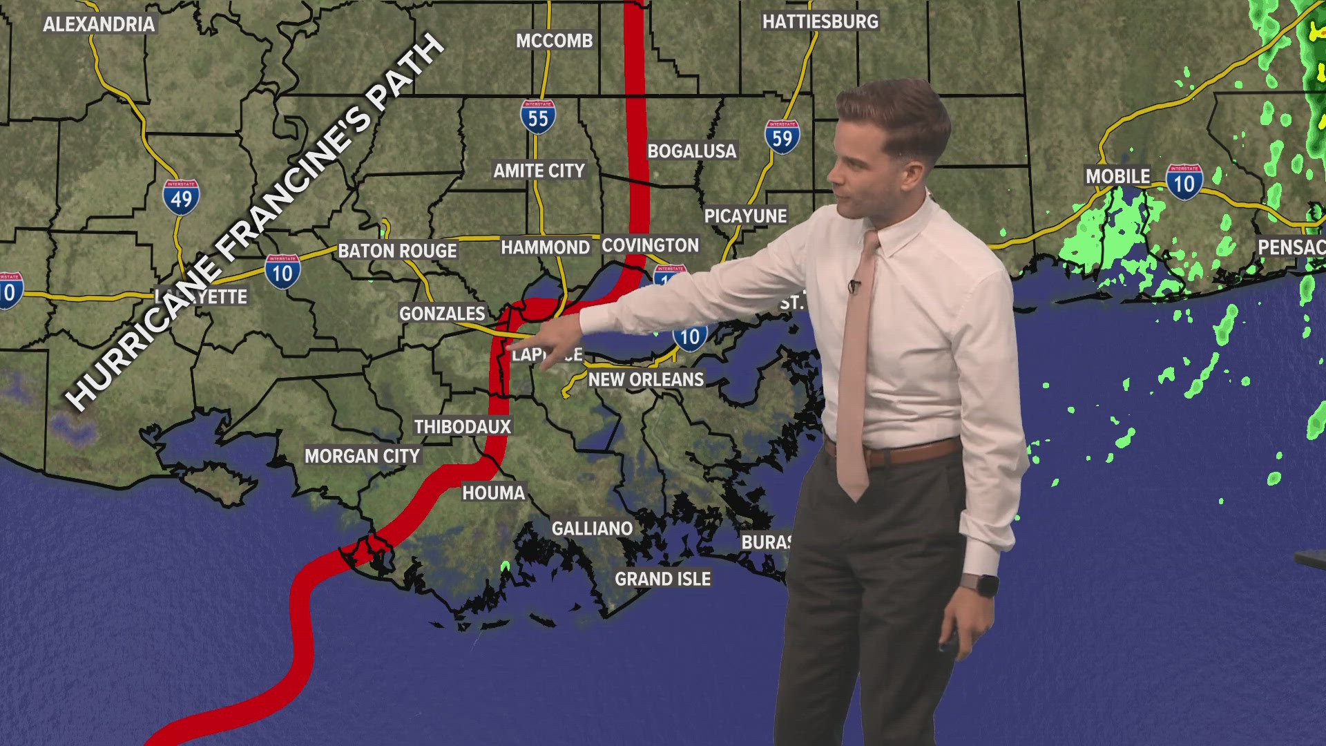
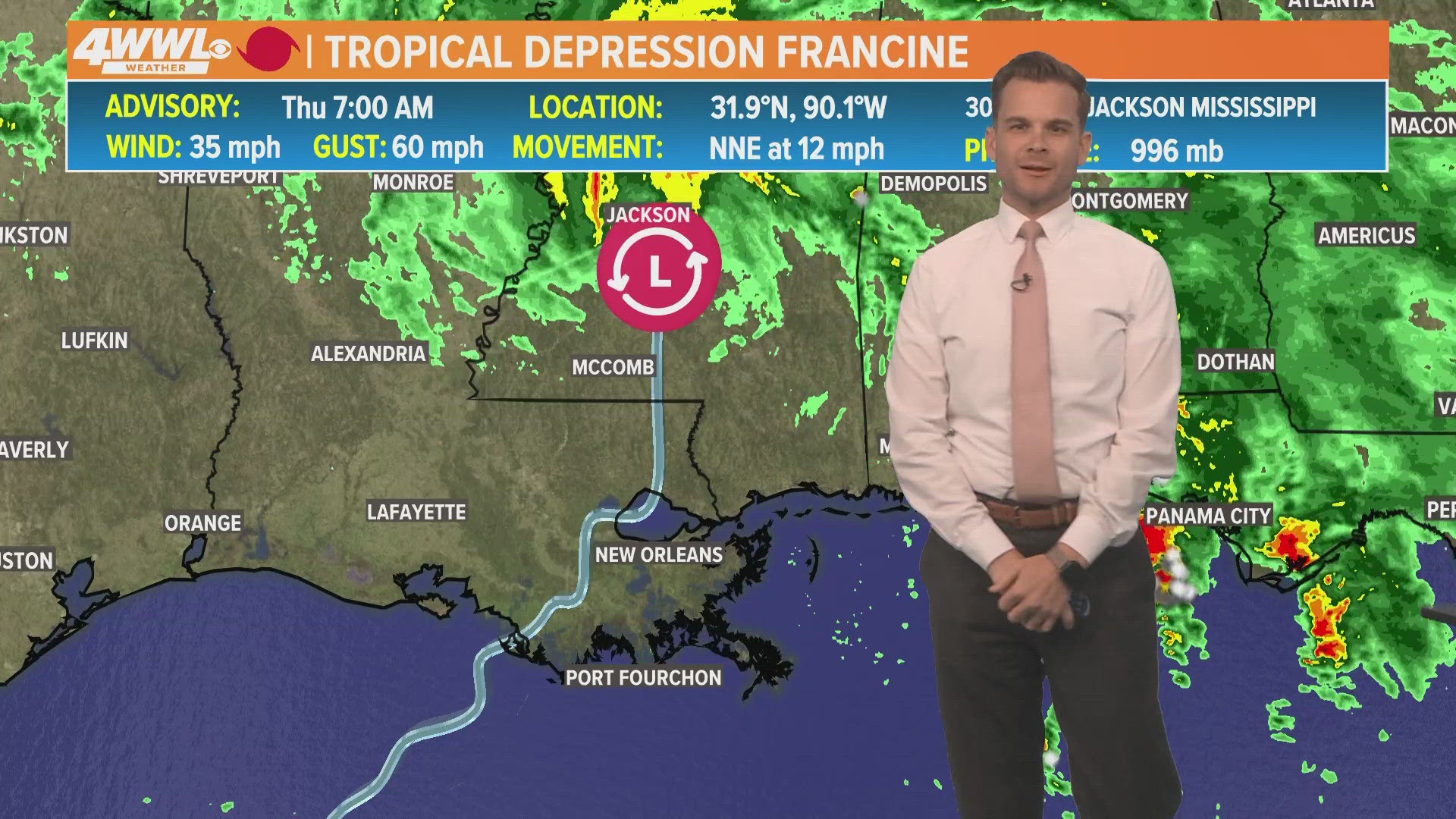
Thursday 12 PM – Here's the path Hurricane Francine took through Louisiana
The storm did not take a straight line as it moved through the state.
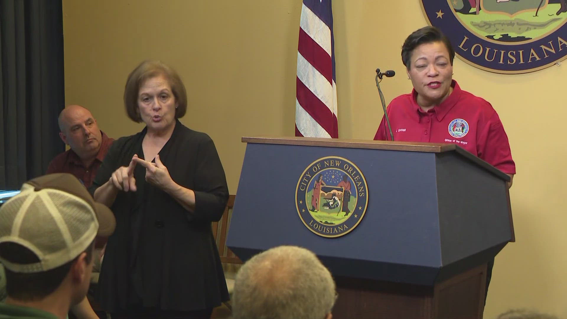
Thursday 11:30 AM – Cantrell provides NOLA updates
Mayor LaToya Cantrell was joined by Collin Arnold, Director, New Orleans Homeland Security and Emergency Preparedness (NOHSEP) and local leaders to provide updates on Hurricane Francine.
Thursday 10:30 AM – Louisiana Insurance Commissioner Tim Temple on insurance claims

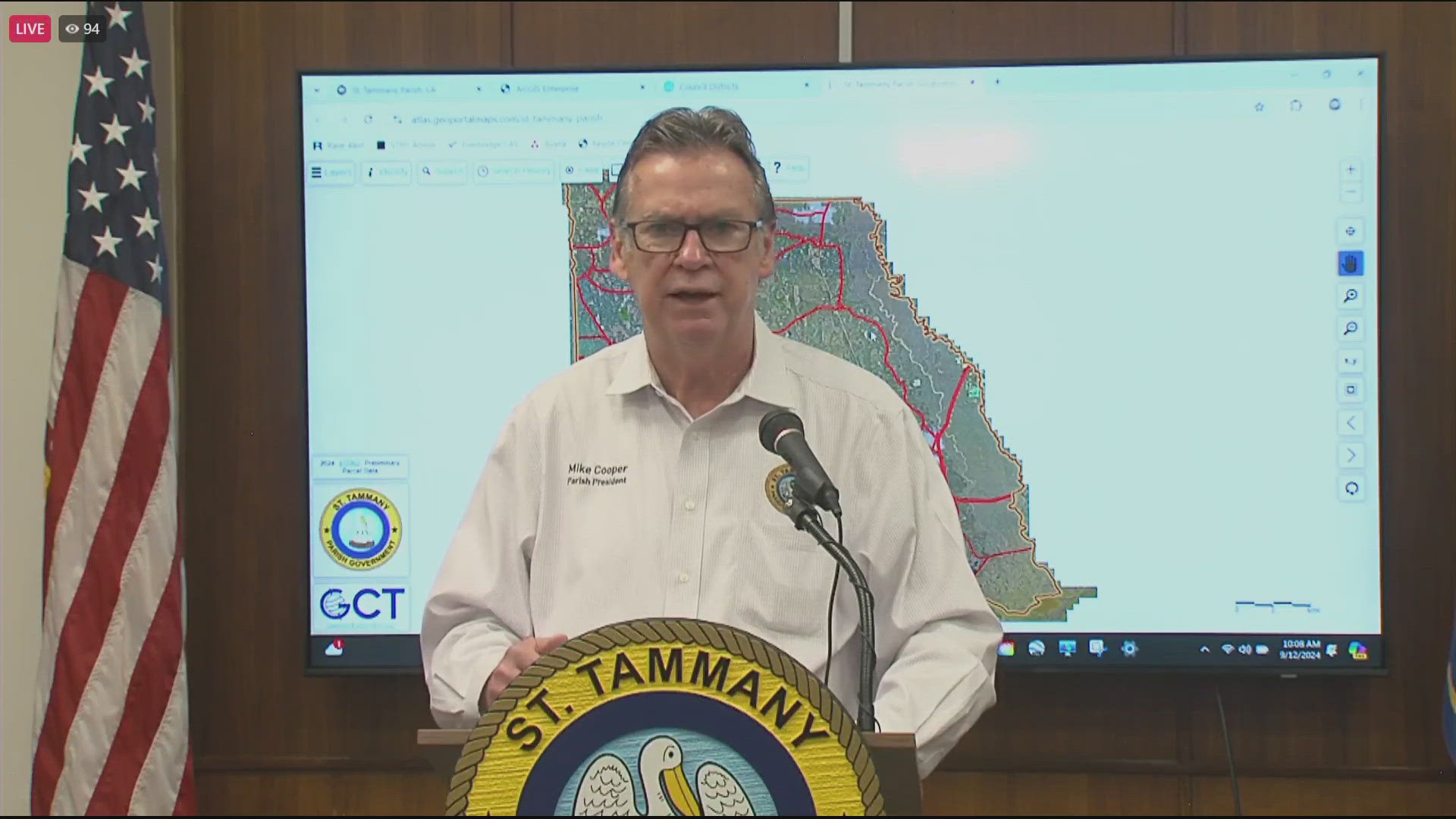
Thursday 10 AM – President Mike Cooper provides Francine impact update for St. Tammany Parish
Thursday 9 AM – Schools announce continued closure, emergency shelter no longer open
Due to widespread power outages, Loyola University has suspended all operations for Thursday, Sept. 12. All classes are canceled and the campus is closed except for essential operations. University officials are assessing the impact of Francine to our campus, and a full update will be provided once these assessments are complete.
St. Charles Parish officials have announced the closure of the Shelter of Last Resort.
As of 8 a.m., the mandatory curfew for Grand Isle was lifted.
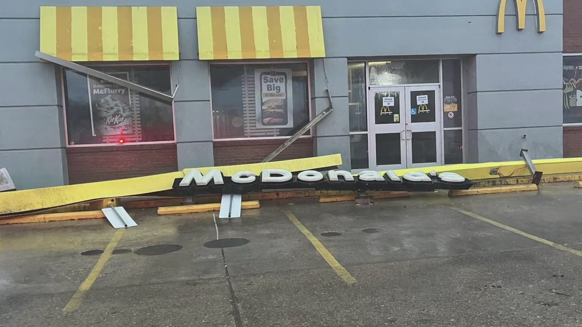
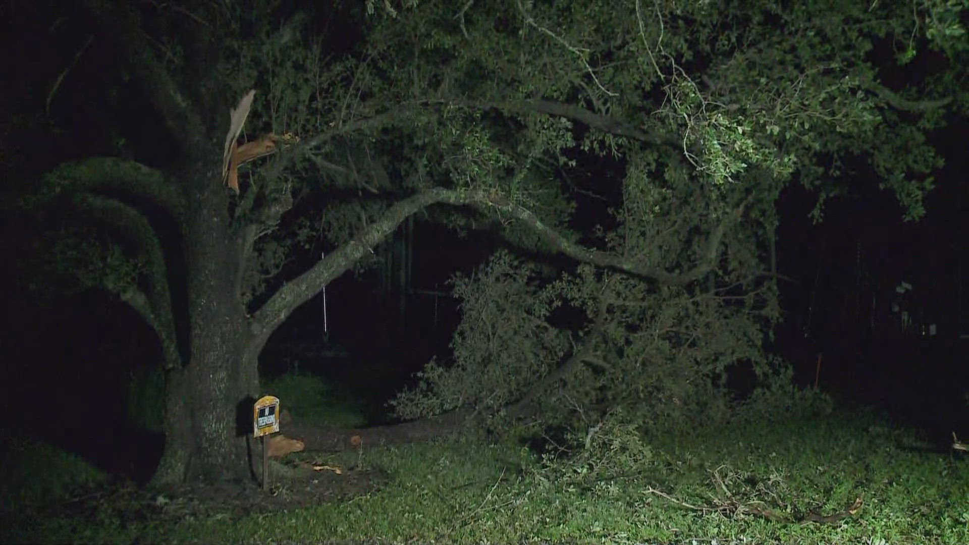
Thursday 8AM – Aftermath of Francine, now downgraded as a tropical depression
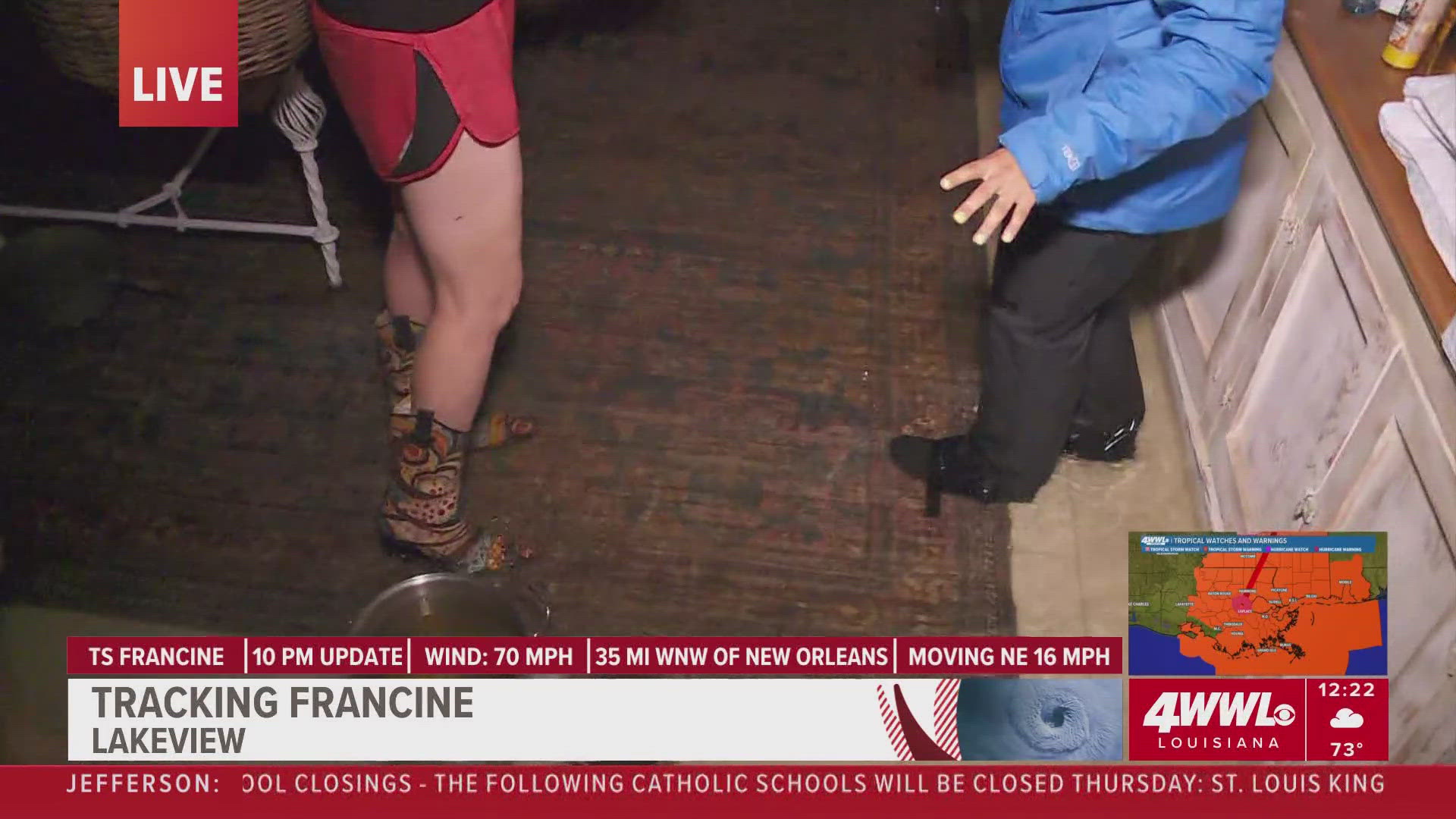
Couple in shock after Lakeview home floods during Hurricane Francine
Thibodaux Damage Update in Lafourche Parish
Update from Cocodrie Outside the Levees
Weather: Post-Francine forecast continues to improve
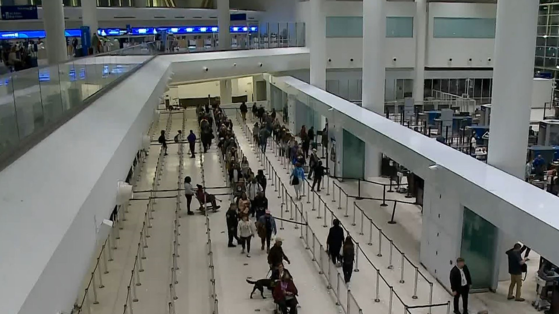
Thursday 7:30 AM – Airlines to gradually resume flight schedule at New Orleans Airport (MSY)
The Louis Armstrong New Orleans International Airport (MSY) announced no significant damage and will remain open and operational as airlines aim to resume flights Thursday morning.
MSY did confirm several flight cancellations, so passengers are urged to check directly with the airline for the latest flight information before arriving at the airport.
Airline contact information can be found at www.flymsy.com/airlines.
Thursday 7 AM – RTA bus service returns with limited schedule, ferry service still suspended
The New Orleans Regional Transit Authority announced bus service is returning Thursday with a limited schedule. Limited bus service will be provided along our streetcar system until further notice as the power returns and our roadway crew works to clear streetcar lines. Paratransit services will provide trips on an as-needed basis and work to support other city and government agencies as needed. Ferry service remains suspended until further notice.
Due to a power outage, our Rideline is currently out of service until further notice.
RTA will continue to communicate service adjustments and other information at norta.com/francine, in real-time via its Le Pass app, and partnering with NOLA Ready. Text NOLAREADY to 77295 for alerts. For more RTA information, follow @neworleansrta on X (formerly Twitter).
Thursday 6AM – St. James Parish President Pete Dufresne provides post-Francine updates
'We are good shape' | Tangipahoa Parish President Robby Miller says following Francine aftermath

Plaquemines Parish damage update post-Francine

Thursday 5 AM – Storm surge potential remains following Francine, rain subsides + Traffic report
WWL Louisiana meteorologist Payton Malone with the latest New Orleans-area forecast following Hurricane Francine sweeping across southeast Louisiana on Wednesday.
Plus, widespread flooding, power outages, public transit service suspensions and Causeway closure highlights New Orleans-area traffic report.
Meanwhile, the Greater New Orleans Expressway Commission announced a tentative time to re-open the Causeway Bridge for 8 a.m. Check back for further information.
Francine Aftermath: Lafourche Parish damage update
Lafourche Parish President Archie Chaisson III talks with WWL Louisiana's Leigha McNeil about damage sustained during Hurricane Francine overnight.
Thursday 4:30 AM – Man still reeling from Ida, keeps spirits high in Lafourche shelter following Francine
WWL Louisiana's Leigha McNeil talks with Raceland man finding emergency shelter at Lockport Community Center following Hurricane Francine.

Thursday 3:30 AM – Francine leaves southeast Louisiana in the dark, 300K still without power

Traffic: DOTD issues road closure due to high water
The Louisiana Department of Transportation and Development announced a full road closure on LA Highway 433 in St. Tammany Parish due to water on the roadway.
The road will open once water recedes. Motorists are urged to find an alternative route.
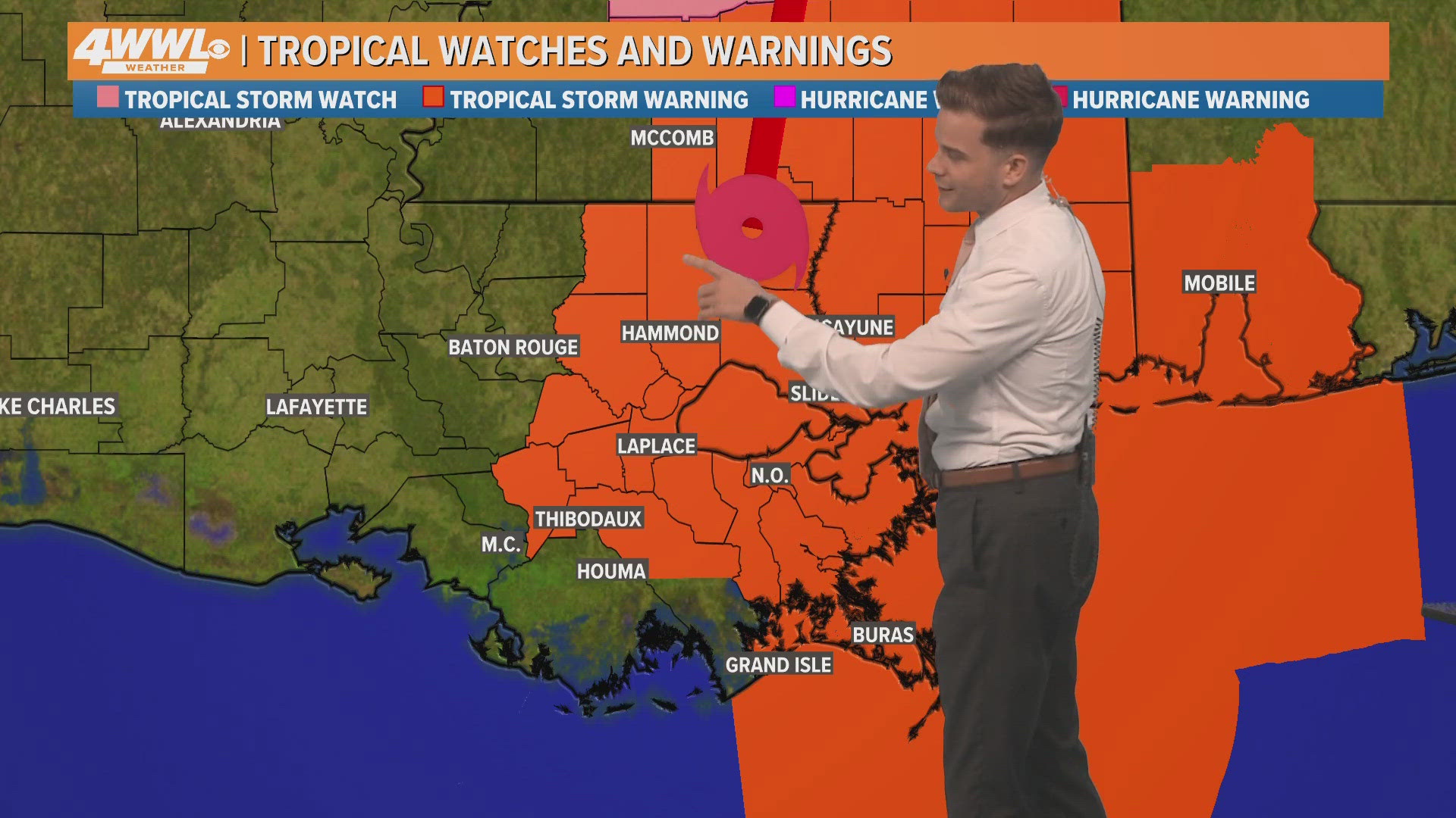
Thursday 3AM – Tropics quiet following Francine, storm surge warnings remain in aftermath
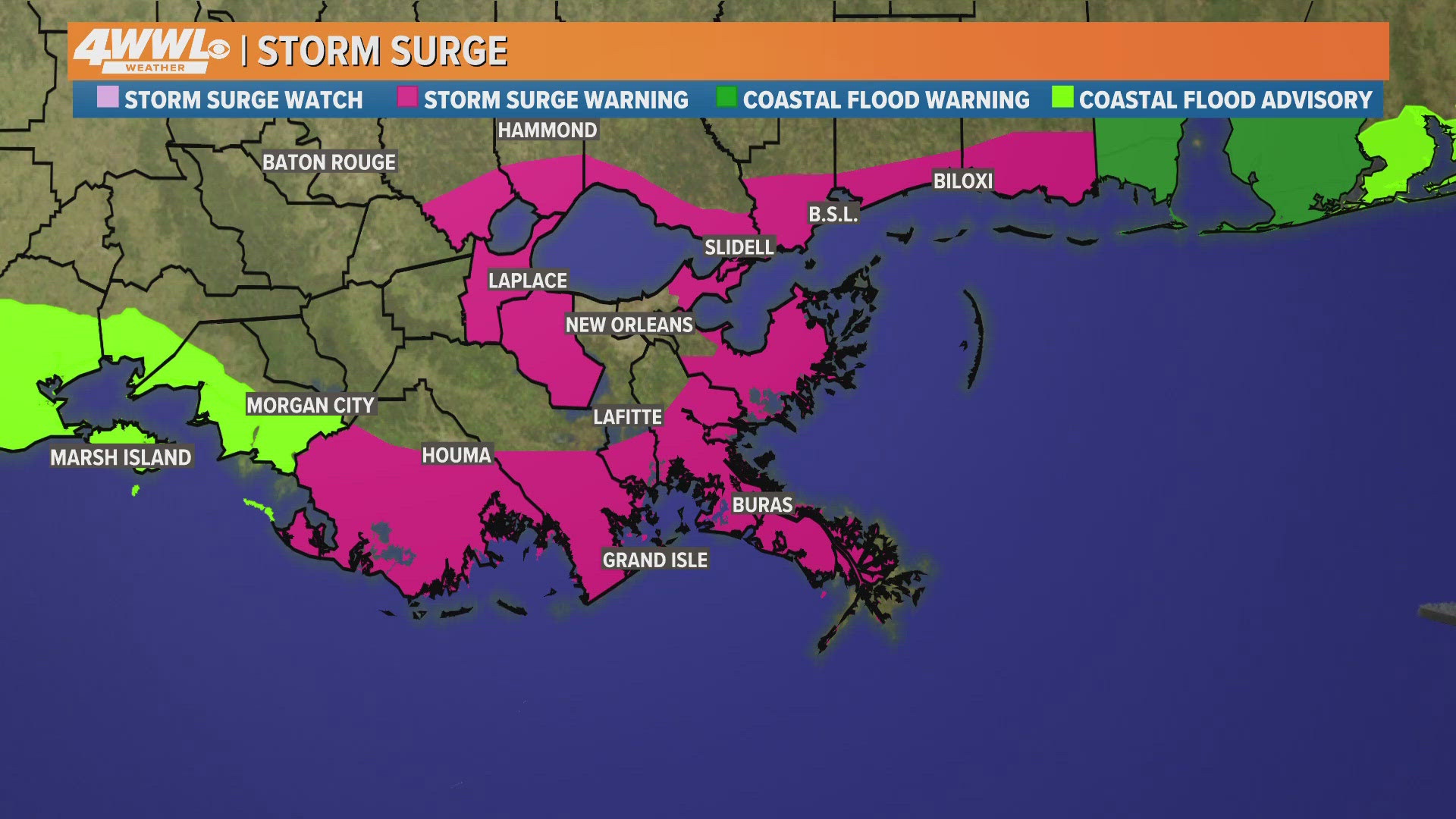
Thursday 2AM – Tropical Storm Warnings still in effect, improvements slow after Francine
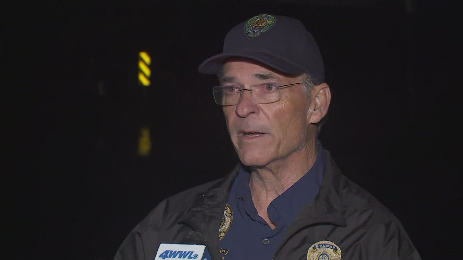
Thursday 1:15 AM – Police Chief updates community on widespread flooding in Kenner
"Unfortunately I see flooding from the lake to the river, there's no part of Kenner that hasn't been affected by the storm," Kenner Police Chief Keith Conley told WWL Louisiana. "In the morning when the sun comes up, we are going to see hundreds of homes have had water intrusion.
"This point from Williams [Boulevard] all the way over to Loyola [Avenue] it's almost a lake," he continued. "It seems like the drainage canal is overwhelmed, the Duncan Canal we came over to get to this point as we picked up some officers moving them around. It's heartbreaking to think that some folks just finished with Ida repairs and got back on their feet and here we go again.
"Haven't seen this kind of flooding from being overwhelmed by this much water from our drainage canals since Katrina, it's sad to say."
Chief Conley said 40-50 cars are stalled out at major intersections as much of Kenner is flooded from Williams Boulevard to Loyola Avenue.
Conley urged residents to continue to shelter in place as police and other first responders continue rescue efforts and assess the widespread damage.
Thursday 1 AM – St. John Francine Update
St. John has received approximately 5-7 inches of rainfall so far with additional amounts possible. With this large amount of rain in a short period of time, significant street and localized flooding is occurring.
In addition, over 8,000 residents are out of power.
Parish Crews are on standby and will go out to access the Parish and clear roadways when weather permits.
Residents should remain indoors and not go out to sight see even once conditions seem to improve.
Thursday 12:30 AM – Street Flood Advisory
A Street Flood Advisory has been issued for parts of St. James, Ascension, Assumption, Iberville, St. John The Baptist until 3:30 a.m.
Thursday 12 AM – Causeway scheduled to reopen
Causeway is scheduled to reopen at 8 a.m.
Wednesday 11:50 PM – Flash Flood Warning issued for parts of Pearl River, St. Tammany, Hancock, Washington
A Flash Flood Warning has been issued for parts of Pearl River, St. Tammany, Hancock, Washington until 3:00 a.m.
Wednesday 10:40 PM – Flash Flood Warning issued for parts of Harrison, Jackson
A Flash Flood Warning has been issued for parts of Harrison, Jackson 1:45 a.m.
Wednesday 10:10 PM – Housing development in Thibodaux evacuated
"The street and some of the people took on water. The sheriff's office got them to the front of the street, and our crew got them loaded on a bus and en route to the shelter. 24 or 26 people, including 8 children," President Archie Chaisson said
Wednesday 9:50 PM – S&WB report 5 backup power generators EMDs down, high canal levels in Hollygrove, Lakeview, Gentilly, maybe N.O. East
Wednesday 9:24 PM – Lafourche Parish Curfew extended until 10 a.m. on Thursday, Sept. 12
Officials said residents should remain sheltered in place until that time. Lafourche Parish Sheriff's Office deputies are actively enforcing the curfew.
Sheriff Craig Webre announced deputies rescued multiple families in the Thibodaux area on Wednesday night who were trapped due to rising water following Hurricane Francine. A total of 26 people were rescued and most were transported to the emergency shelter at the Lockport Community Center.
Wednesday 9 PM – St. Charles Parish ask residents to conserve water
Officials said please limit non-essential sewer usage including washing clothes, dishes, ect.
Wednesday 8:54 PM – 911 issues resolved for AT&T and T-Mobile Customers
"Orleans Parish Communications District/New Orleans 9-1-1 services are fully online and able to receive calls. Our communications center is fully staffed and continues 24/7 operation," Orleans Parish Communication District said in a statement.
Wednesday 8:45 PM – Flash Flood Warning issued for parts of the New Orleans Metro
Wednesday 8:30 PM – Orleans Parish residents asked to conserve water by Sewerage and Water Board of New Orleans
Wednesday 8 PM – AT&T and T-Mobile customers having issues contacting 911 from mobile devices/cell phones
Customers having difficulty calling Orleans Parish 911 are asked to use the backup 10-digit emergency number at 504-671-3600.
This 10-digit number will get you to the same New Orleans 911 Operators and communications specialists. Once you have connected, do not hang up, as it will put you to the back of the line.
"We’ve learned that AT&T and T-Mobile customers are having difficulty contacting 911 when trying to connect from their mobile device. This is apparently impacting AT&T and T-Mobile customers wide area of the storm’s impact, including Orleans Parish," Orleans Parish Communication District said in a statement.
Wednesday 7:20 PM – Tornado Warning issued for areas in St. Tammany
A Tornado Warning has been issued for areas in St. Tammany until 7:45PM
Wednesday 6:40 PM – Flash Flood Warning issued for southeast Louisiana
A Flash Flood Warning was issued until 9:30 p.m. for southeast Louisiana, according to NOLA Ready.
Wednesday 6 PM – Causeway closed
The Causeway is closed due to high winds, according to Total Traffic New Orleans.
Wednesday 5:50 PM – Lakeshore Drive closed
Lakeshore Drive across the NOLA lakefront has been closed due to lake water coming across the roadway, according to Total Traffic New Orleans.
Wednesday 5:30 PM – NOPD finds child near Mirabeau and Paris Avenues
The child was found on Wednesday around 2:30 p.m. near the intersection of Mirabeau and Paris Avenues.
Wednesday 5:20 PM – Plaquemines Parish ask residents to conserve water
Due to the recent impact of Hurricane Francine, we are experiencing power outages and an influx of rainwater affecting our sewer lift stations. To ensure the integrity of our water management systems and to assist in mitigating further issues, we kindly ask all residents to limit their water usage.
Specifically limiting the following activities:
• Dishwashing
• Toilet flushing (only flush when absolutely necessary)
• Showering
• Any other non-essential water use
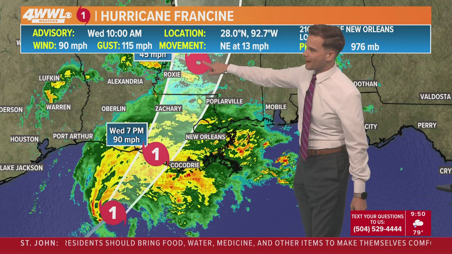
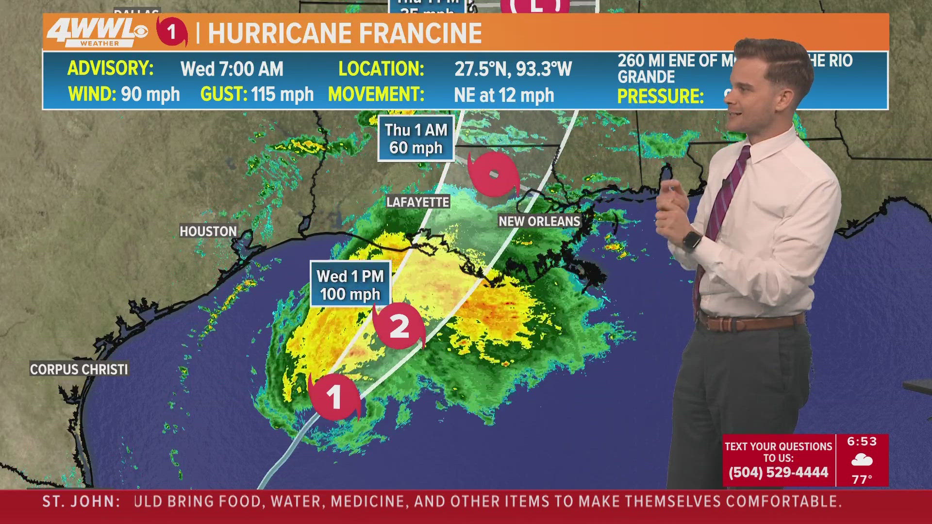
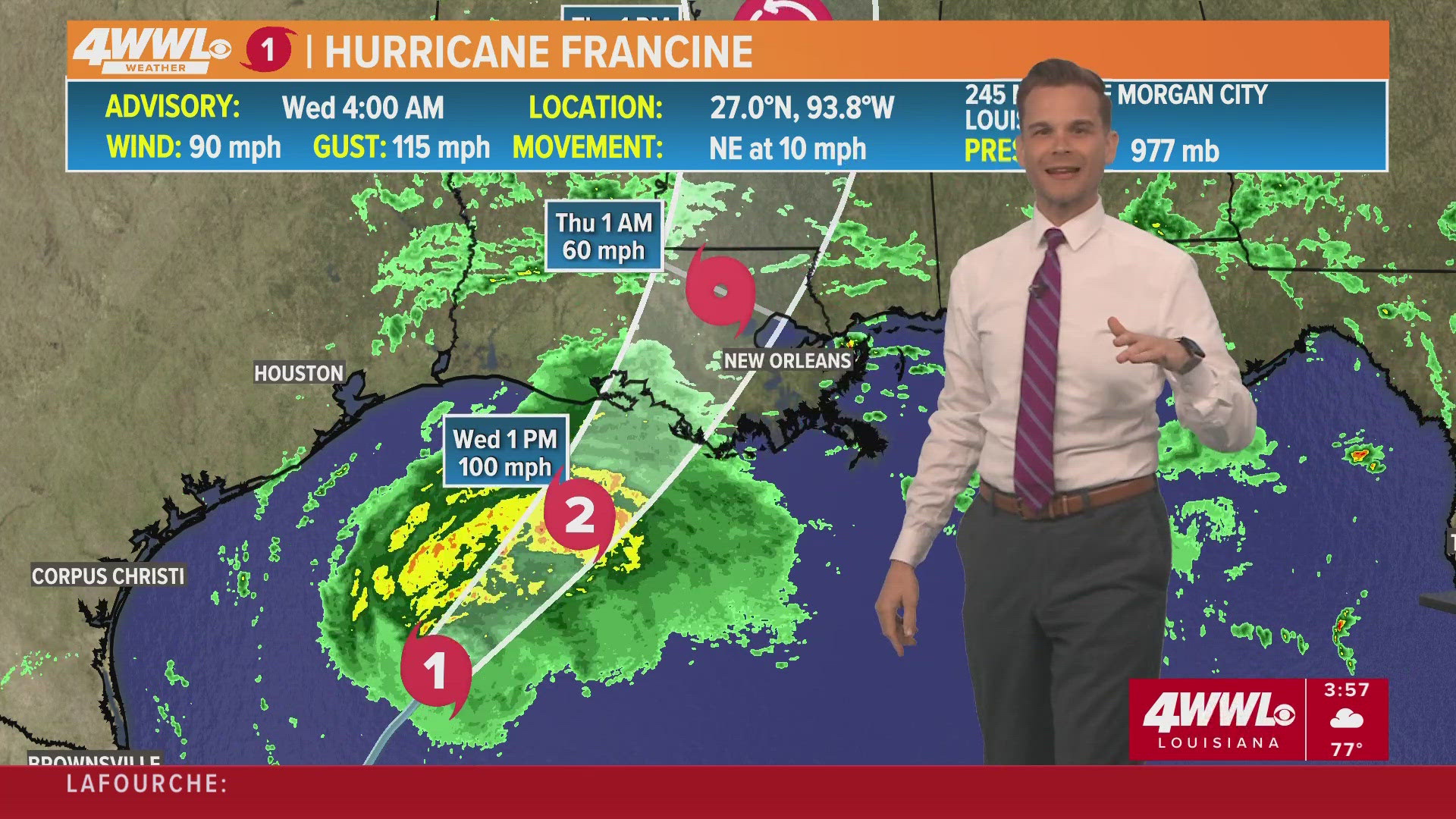
Wednesday 5 PM – Francine makes landfall as a Category 2 hurricane
Francine made landfall in Terrebonne Parish, about 30 miles south-southwest of Morgan City, as a Category 2 hurricane.
Wednesday 4:17 PM – Jefferson Parish ask residents to conserve water to prevent sewerage system backup
Wednesday 4 PM – Hurricane Francine now a Cat 2
Hurricane Francine is a Category 2 with 100 mph winds just before landfall in Terrebonne Parish. Expect damaging winds to spread over SE Louisiana this evening lasting into tonight. Another Gulf storm that pulls a last minute intensity surprise.
Wednesday 3 PM – Kenner officials asking residents to avoid using dishwashers and washing machines during storm
Wednesday 2:30 PM – Entergy New Orleans Update
Entergy says they are prepared well in advance and that many crews are coming into the city to help with restoration efforts after the storm.
"If you have an outage, crews will be there as soon as they can when it is safe," Entergy officials said.

French Quarter Fire
NOFD is working to contain a fire on Piety and Dauphine.
Wednesday 2 PM – New Orleans Sewerage and Water Board on how they have prepared for Hurricane Francine

Wednesday 1:45 PM – Street Flood Advisory issued for parts of Orleans, Jefferson, St. Bernard, Plaquemines
Wednesday 1:40 PM – VCA's Louisiana Animal Hospitals Closed for Hurricane Francine
VCA Animal Hospitals has closed the following local hospitals for all services today, September 11:
- VCA Causeway Animal Hospital
1315 Causeway Boulevard, Metairie, LA 70001
504-828-2700 - VCA Airline Animal Hospital
5105 Airline Drive, Metairie, LA 70001
504-888-0400 - VCA All Pets Animal Hospital
9308 Perkins Road, Baton Rouge, LA 70810
225-767-2462 - VCA Algiers Animal Hospital
3807 General De Gaulle Drive, New Orleans, LA 70114
504-364-1446
These hospitals will reopen tomorrow, (Thursday) September 12th, if weather conditions are safe and power is restored.
Wednesday 1:30 PM – Grand Isle curfew
As of 1:00 p.m. on Wednesday, September 11, 2024, Mayor David Camardelle has called a mandatory curfew. Grand Isle Police Department will be patrolling and enforcing this curfew.
Wednesday 12:30 PM – Tornado Warning issued for Plaquemines Parish, Watch issued for 20 parishes/counties
The National Weather Service issued a Tornado Warning for areas in Plaquemines Parish, including Buras, Venice, Triumph to the mouth of the Mississippi River until 1 p.m.
Take cover immediately if in the area.
Meanwhile, a Tornado Watch has been issued for the following 16 parishes and four counties in Mississippi until 11 p.m.
Louisiana:
- Ascension
- Assumption
- Ascension
- Assumption
- Iberville
- Jefferson
- Lafourche
- Livingston
- Orleans
- Plaquemines
- St. Bernard
- St. Charles
- St. James
- St. John the baptist
- St. Tammany
- Tangipahoa
- Terrebonne
- Washington
Mississippi:
- Hancock
- Harrison
- Jackson
- Pearl River
Wednesday 11:30 AM – Hurricane Francine's center 205 miles from New Orleans, NHC hourly storm update
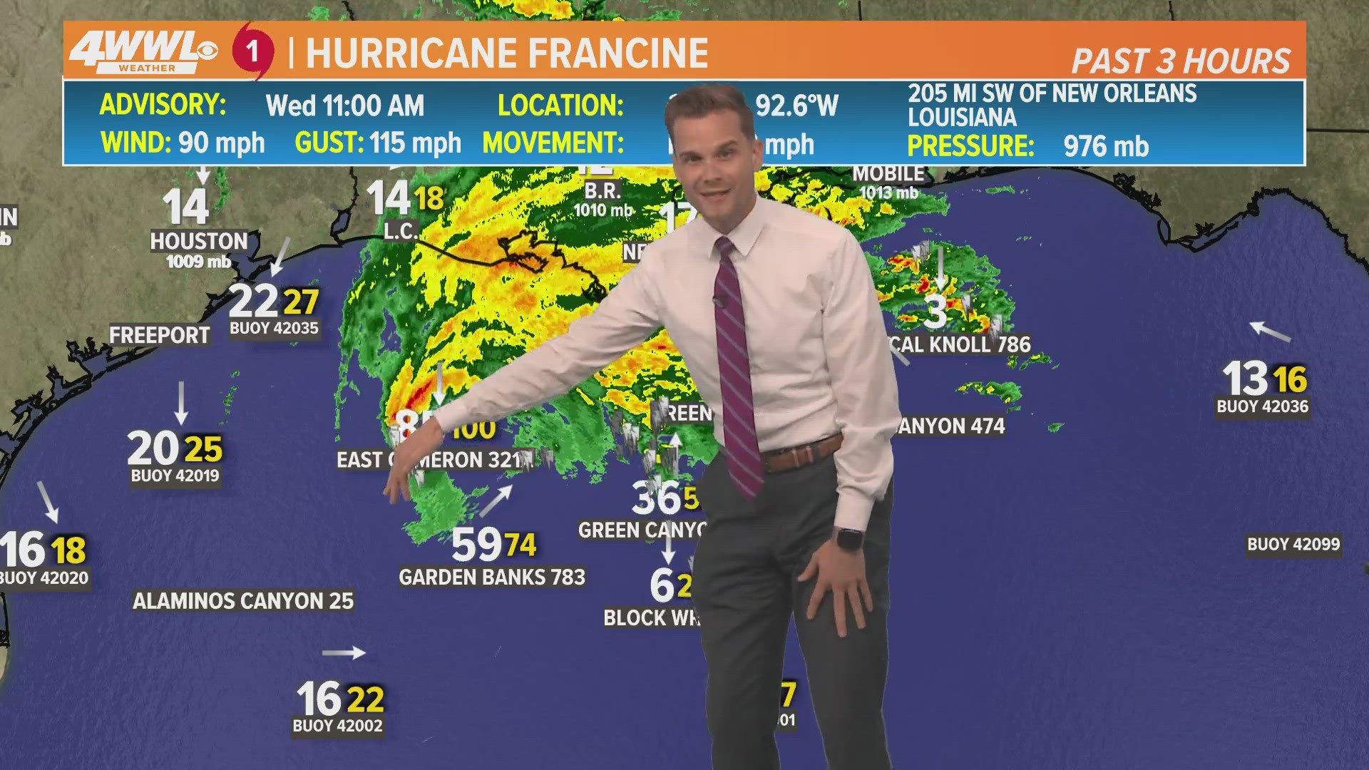
Governor Landry and GOHSEP officials give an update on Hurricane Francine preparations
Louisiana Governor Jeff Landry and GOHSEP officials give the latest information. Landry says the "time to prepare has passed."

DOTD announces road closures, ferry service interruption
The Louisiana Department of Transportation and Development announces that high water warnings are in effect for the following state highways.
- LA 82/27 in the Holly Beach and Johnson Bayou areas
- LA 27 North from LA 82 through Hackberry and Kelso Bayou
- LA 82 at Rex Street in Cameron
DOTD has posted signs warning motorists of high water along these routes.
Officials have also advised motorists that the Plaquemine/Sunshine ferry in Iberville Parish closed at 10 a.m. due to expected weather.
Wednesday 11:15 AM – RTA in New Orleans switches from streetcar service to bus only service
Ahead of Francine RTA is shifting to bus transit services only starting at noon. Ferry & streetcar operations will remain suspended until further notice.
Wednesday 11:00 AM – SELA Flood Protection Authority completed all closures of Flood Gates
All hurricane protection floodgates are closed. SLFPA-W will begin reopening land-based floodgates and will reopen navigation gates when storm conditions subside and water levels allow.
Wednesday 10:30 AM – New Orleans issues Shelter in Place order for 11:00 a.m.
Francine is expected to make landfall along the LA coast this evening as a Cat 1. By 11 a.m., everyone in New Orleans should stay off the roads and shelter in place.
St. Charles Parish officials also urge residents to stay off the streets as the weather worsens.
Wednesday 10 AM – Francine stays steady, targets 6 p.m. landfall
Wednesday 9:30 AM – Louisiana State Police issue statewide advisory
We’re pushing that now. Encouraging everyone to seek shelter, unless they are evacuating. Keep off the road unless absolutely necessary. Stay off the roads during the storm, and after, to let emergency crews access areas as needed to assess damage.
Wednesday 8:30 AM – Parish presidents check in as hurricane prep rapidly continues ahead off landfall later in the day
Jefferson Parish President Cynthia Lee Sheng update:

St. John Parish President Jaclyn Hotard update:

Lafourche Parish President Archie Chaisson III update:

Terrebonne Parish President Jason Bergeron update:

St. Bernard Parish President Louis Pomes update:

Wednesday 7 AM – Francine is not rapidly intensifying
The latest update from NHC shows that Hurricane Francine is maintaining the same intensity and not rapidly increasing.
Wednesday 6:30 AM – What Louisiana can expect when Francine makes landfall
Hurricane Francine could strike Louisiana as a Category 2 storm with heavy rain on the northern side.
National Hurricane Center Director Michael Brennan explains what to expect when Hurricane Francine makes landfall.
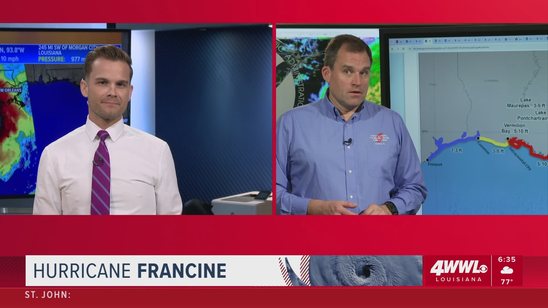
WWL Louisiana meteorologist Brooke Laizer with an in-depth look at the local impact once Hurricane Francine makes Louisiana landfall.
Terrebonne Parish President Jason Bergeron says shelters are open, some sandbags still available, the biggest concern is the storm surge against the levee system.

Wednesday 4 AM – Hurricane Francine projected to upgrade to Cat. 2
Hurricane Francine still a healthy Category 1 and could become Cat. 2 before landfall later Wednesday afternoon/evening. Preps need to be rushed to completion. Tropical storm force winds arrive throughout the afternoon with strong winds lasting into tonight.
Wednesday 2:30 AM – Lafourche preps for Francine following mandatory evacuation
WWL Louisiana's Leigha McNeil with Lafourche Parish President Archie Chaisson, III ahead of Wednesday landfall of Hurricane Francine.

EVACUATIONS:
MANDATORY: residents in FEMA/State Housing and south of Leon Theriot Lock in Golden Meadow including Port Fourchon
• PARISH-WIDE CURFEW TAKES EFFECT AT NOON, AND REMAINS IN EFFECT TILL SUNRISE THURSDAY
All businesses should be closed by noon on Wednesday so that employees can make it home before the strongest storm impacts begin.
VOLUNTARY: lower Bayou Blue, Eagle Island Road, residents in mobile homes and low lying areas, and anyone feeling vulnerable
SHELTER (Open now):
• Lockport Community Center - 5610 Highway 1. Please remember to bring at least two days’ worth of food, water, medicine and bedding. Also, remember to bring your charging banks and charging cables for portable electronic devices.
• 6 people there now, more are expected to pull up
• Two days' worth of food water, and charging cables
ROAD CLOSURES:
• Canal Street in Lockport is CLOSED under the Company Canal Bridge
• Go to 511la.org for all state road closures
SANDBAGS:
• All self-fill locations (bring a shovel): Remaining open until weather conditions are not safe.
• Oak Ridge Community Park: Golden Meadow---Elderly/Disabled Pickup (25 bags): reopens at 6 a.m. on Wednesday, September 11th until weather conditions are not safe.
Wednesday 1 AM – Hurricane Francine slightly stronger, winds up to 90 mph
Landfall is expected before 7 p.m. Highest storm surge expected in Terrebonne Parish.
Tuesday 11:20 PM – Louis Armstrong New Orleans International Airport (MSY) says airlines have canceled over 130 flights
Read the full statement:
"The Louis Armstrong New Orleans International Airport is monitoring weather conditions and preparing for potential impacts from Hurricane Francine. The Airport will remain open unless conditions become unsafe. Individual airlines determine if or when to cancel or delay flights. As of Tuesday evening, over 130 cancellations were made by the airlines at MSY on Wednesday, Sept. 11.
Passengers with travel scheduled in the coming days are encouraged to check directly with their airlines for the latest flight information.
In order to minimize delays in processing through the check-in counters, passengers who need to reschedule flights should work with their airlines to rebook before coming to the Airport."
Tuesday 9:45 PM – President Biden Approves Louisiana Emergency Declaration
President Joe Biden approved Governor Landry's Emergency Declaration request.
"President Joseph R. Biden, Jr. declared that an emergency exists in the State of Louisiana and ordered Federal assistance to supplement State, tribal, and local response efforts due to the emergency conditions resulting from Tropical Storm Francine beginning on September 10, 2024, and continuing," in a statement.
"The President’s action authorizes the Department of Homeland Security, Federal Emergency Management Agency (FEMA), to coordinate all disaster relief efforts which have the purpose of alleviating the hardship and suffering caused by the emergency on the local population, and to provide appropriate assistance for required emergency measures, authorized under Title V of the Stafford Act, to save lives and to protect property and public health and safety, and to lessen or avert the threat of a catastrophe."
Tuesday 8:30 PM – Orleans City Hall Closure
City Hall closed until Thursday, Sept. 12.
Tuesday 8 PM – Flood Protection Authority East
According to Flood Protection Authority East, "We are continuously monitoring the storm. Between yesterday and today we have closed 32 Floodgates in Orleans, St. Bernard and East Jefferson parishes," a spokesperson said in a statement.
Tuesday 7:45 PM - Entergy New Orleans, Cleco outage
According to the Entergy outage map, customers are without power. At one point, 9,600 customers in the Marigny and 9th Ward neighborhoods were without power, an Entergy spokesperson said in a statement.
They said the outage was caused by a breaker failure, and power was quickly restored.
Entergy's full statement:
“Entergy New Orleans is aware of an outage that impacted approximately 9,600 customers in the Marigny and 9th Ward neighborhoods tonight. Entergy crews worked as quickly and safely as possible to restore service. All customers were restored as of 8:55. The cause remains under investigation at this time, but initial findings indicate a breaker failure."
Nearly 400 customers are without power in Jefferson Parish. In Plaquemines Parish there are 160 impacted by an outage.
At one point 121 people experienced an outage in St. Bernard Parish.
According to Cleco's outage map, around 9 p.m. outages were reported in Slidell with 612 customers without power.

View Entergy's outage map here.
View Cleco's outage map here.
Tuesday 7:40 PM - Mayor Cantrell signs Emergency Proclamation in advance of Hurricane Francine
Click here to view the emergency proclamation.
City Hall will be closed on Wednesday, Sept. 11, and Thursday, Sept. 12, due to the expected severe weather. This decision was made to ensure the safety of residents and City employees.
Tuesday 7:30 PM - Some Ochsner clinic and urgent care locations to close or have modified hours Wednesday
Clinics are expected to reopen and elective procedures are expected to resume on Thursday, Sept. 12, pending storm status and operations.
- Bayou – Clinics closed and elective procedures will be canceled all day Wednesday, September 11.
- South Shore & River Region – Clinics closed and elective procedures will be canceled all day Wednesday, September 11.
- Northshore & Mississippi Gulf Coast – Clinics will be closed all day Wednesday, September 11, and SMH Regional Cancer Center and St. Tammany Cancer Center will be open until noon. Select elective and outpatient procedures as well as a few standalone clinics will maintain operations in the morning.
- Baton Rouge - Clinics will be closed all day Wednesday, September 11. Select elective and outpatient procedures as well as a few standalone clinics will maintain operations in the morning.
- Lafayette
- Clinic appointments at all Ochsner Lafayette General clinic locations will be canceled all day Wednesday, September 11.
- Ochsner Acadia General Hospital (Crowley) & Ochsner American Legion Hospital (Jennings) will continue normal operations and elective procedures until 12 p.m. on Wednesday, September 11. All elective procedures after noon tomorrow at these locations will be canceled for the remainder of the day.
Urgent Cares
- Bayou Region Urgent Care locations will be closed all day tomorrow, September 11. South Shore and Lafayette Urgent Care locations will close at noon tomorrow, September 11. We expect urgent care locations in all areas to resume normal operations on Thursday, September 12 pending extenuating circumstances.
Tuesday 6:50 PM - RTA to shift to a reduced schedule or suspend service
Ferry services have been suspended until further notice; bus/shuttle service via the 103 Line is in place.
Rideline service will remain available by calling (504) 248-3900.
Tuesday 6:30 PM - Francine strengthens into a hurricane
Tuesday 5:50 PM – Neutral Ground Parking allowed
NOLA Ready said neutral ground parking is allowed until 6 p.m. on Thursday, Sept. 12.
Tuesday 4:50 PM – Curfew set in place for Lafourche, Washington, and Terrebonne Parishes
Lafourche Parish curfew to start at noon on Wednesday Sept. 11 and end at sunrise on Thursday, Sept. 12.
Terrebonne Parish under a mandatory curfew for all Zone 1 areas south of the Morganza Levee system, starting at 7 p.m. until further notice. A parish wide curfew will go into effect on Wednesday, Sept. 11 starting at 8 a.m. until further notice.
Zone 1 areas:
- South of Pointe-Aux-Chenes Floodgate
- South of Bayou Terrebonne Floodgate in Lower Montegut
- Isle de Jean Charles
- South of Bayou Petite Caillou Floodgate including Cocodrie
- South of levee road ramp on Four Point Road in Lower Dulac
- South of Lower Dularge Floodgate
Washington Parish curfew to start at 10 p.m. on Wednesday, Sept. 11 until noon on Thursday, Sept. 12
Tuesday 3:50 PM – Hurricane Watch Issued for New Orleans, Slidell, Baton Rouge and Hammond
Tuesday 2:30 PM – St. John Parish Voluntary Evacuation
St. John Parish President Hotard issued a voluntary evacuation for St. John Parish due to Tropical Storm Francine.
Temporary shelters at East St. John Preparatory School and West St. John High School Gymnasium will open Wednesday, September 11, 2024, at 8:00 a.m. for residents seeking secure shelter.
Tuesday 2 PM – St. Tammany Parish Emergency Operations Center discuss storm preps
All St. Tammany Parish schools, public and otherwise, will be closed Wednesday, St. Tammany Parish President Mike Cooper said during the press conference.
Tuesday 1:45 PM – New Orleans Library locations closed
All Library locations will close at 5pm today, Wednesday, September 10. They will remain closed tomorrow, Wednesday, September 11, and Thursday, September 12
Tuesday 1 PM – Governor Landry Requests Presidential Emergency Declaration
“After declaring a State of Emergency, we have now determined that this storm is of such severity that an effective response is beyond the capabilities of the state and local governments. This federal assistance is needed to save lives and property, and I look forward to President Biden quickly approving this request," Governor Jeff Landry said.
Tuesday 1 PM – LPSO offices closing
The Lafourche Parish Sheriff’s Office announced administrative offices will close at noon on Tuesday, September 10 and remain closed until further notice.
Tuesday 12:35 PM – Port NOLA Terminal operations
Terminal operations will be closed. Terminal operators are expected to resume Thursday, September 12, 2024, following damage assessments.
Tuesday 12:15 PM South shore flood gates closing in New Orleans
Lakefront Management Authority said that the FPA is not planning to close the gate crossing at Lake Terrace, Rail St or Marconi. The main gate at Lakeshore Dr and Lake Marina Dr is scheduled to close around 4 p.m. today.
Tuesday 11:36 AM – Grand Isle issues mandatory evacuation
Grand Isle Mayor David Camardelle issued a mandatory evacuation order for Tuesday, September 10.
Tuesday 11:30 AM – Governor Jeff Landry to Speaks at GOHSEP Storm Preparedness Press Conference
Tuesday 11:15 AM – LCMC announces closings
All LCMC Health hospitals have activated their hurricane plan and will go into lockdown mode Wednesday, September 11, at 7 a.m. in preparation for Tropical Storm Francine.
All clinics and urgent cares will be closed on Wednesday, and elective procedures will be canceled. Normal operations will resume at all LCMC Health locations on Thursday.
Tuesday 11:10 AM – Orleans Civil Court Closure
“Due to the inclement weather expected to impact the New Orleans Metro area, the Orleans Parish Civil District Court, First and Second City Court will close today September 10, 2024 at 12:00 noon. The Courts will be closed tomorrow, Wednesday, September 11, 2024 and Thursday, September 12, 2024. The Courts are expected to reopen on Friday, September 13, 2024 for normal business hours.”
Tuesday 11 AM – Entergy New Orleans suspends disconnects
Due to anticipated impacts from Tropical Storm Francine, Entergy New Orleans is suspending all disconnects due to non-payment through the end of the week.
Tuesday 11 AM – Jefferson Parish cancels trash and recycling
No curbside garbage and bulk waste collection on Wednesday. All Jefferson Parish trash drop-off sites and the Jefferson Parish Landfill will be closed. Residents are reminded to remove and secure their trash cans.
Tuesday 10:40 AM – City of New Orleans cancels trash and recycling
The City of New Orleans Department of Sanitation today announced that trash and recycling collections had been canceled for Wednesday, Sept. 11, due to the forecasted impacts of Tropical Storm Francine.
- Trash and recycling collection for Wednesday locations will occur on Thursday
Trash and recycling collection for Thursday locations will occur on Friday
Trash and recycling collection for Friday locations will occur on Saturday
Tuesday 10 AM – Francine track shifts east
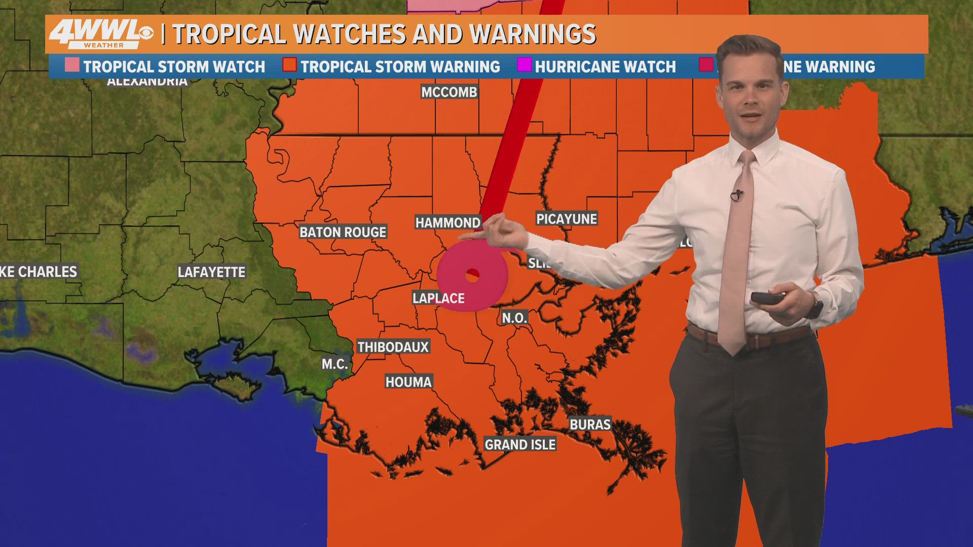
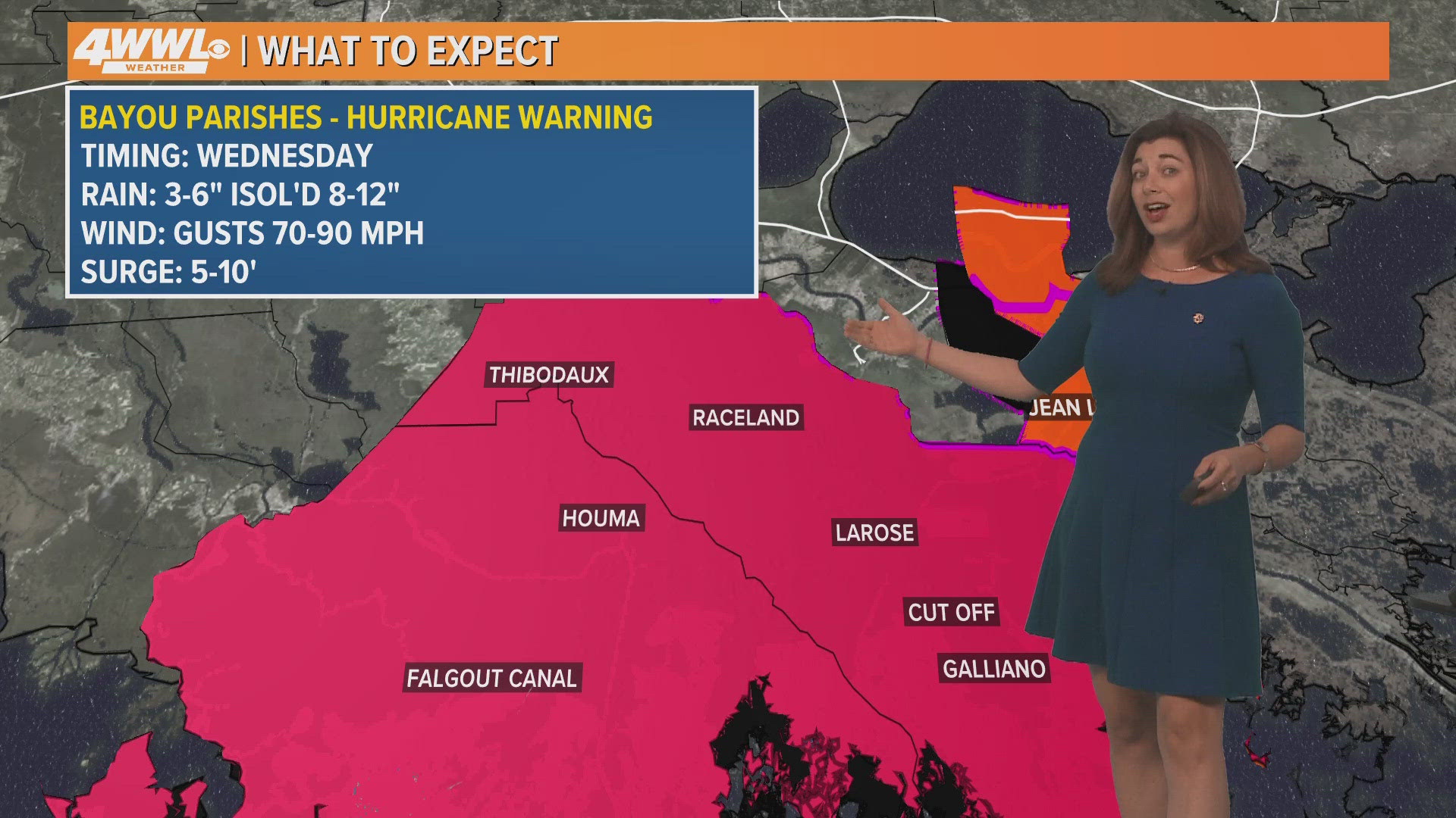
Tuesday 7 AM – Tropical Storm Warning issued, Hurricane Warning issued for bayou parishes
Orleans Parish – Tropical Storm Warning Issued
From the National Weather Service:
TROPICAL STORM WARNING IN EFFECT
Tropical Storm Warning issued September 10 at 7:05AM CDT by NWS New Orleans LA
A Tropical Storm Warning means tropical storm-force winds are
expected somewhere within this area within the next 36 hours
* LOCATIONS AFFECTED
- New Orleans
- Lakefront Airport
* WIND
- LATEST LOCAL FORECAST: Tropical storm force winds remain
possible
- Peak Wind Forecast: 15-25 mph with gusts to 45 mph
- THREAT TO LIFE AND PROPERTY THAT INCLUDES TYPICAL FORECAST
UNCERTAINTY IN TRACK, SIZE AND INTENSITY: Potential for wind 39
to 57 mph
- The wind threat has remained nearly steady from the
previous assessment.
- PLAN: Plan for hazardous wind of equivalent tropical storm
force.
- PREPARE: Remaining efforts to protect property should be
completed as soon as possible. Prepare for limited wind
damage.
- ACT: Move to safe shelter before the wind becomes hazardous.
- POTENTIAL IMPACTS: Limited
- Damage to porches, awnings, carports, sheds, and unanchored
mobile homes. Unsecured lightweight objects blown about.
- Many large tree limbs broken off. A few trees snapped or
uprooted, but with greater numbers in places where trees
are shallow rooted. Some fences and roadway signs blown
over.
- A few roads impassable from debris, particularly within
urban or heavily wooded places. Hazardous driving
conditions on bridges and other elevated roadways.
- Scattered power and communications outages.
* STORM SURGE
- No storm surge inundation forecast
Lafourche Parish – Hurricane Warning Issued
From the National Weather Service:
Upper Lafourche
7:05 am CDT Tue Sept 10, 2024
...hurricane warning in effect...
A hurricane warning means hurricane-force winds are expected
somewhere within this area within the next 36 hours
* locations affected
- Thibodaux
- Raceland
- Larose
* wind
- latest local forecast: tropical storm force winds remain possible
- peak wind forecast: 20-30 mph with gusts to 55 mph
- threat to life and property that includes typical forecast uncertainty in track, size and intensity: potential for wind 58 to 73 mph
- the wind threat has remained nearly steady from the previous assessment.
- plan for dangerous wind of equivalent strong tropical storm force.
- prepare: remaining efforts to protect life and property should be completed as soon as possible. prepare for significant wind damage.
- act: move to safe shelter before the wind becomes hazardous.
- potential impacts: significant
- Some damage to roofing and siding materials, along with damage to porches, awnings, carports, and sheds. a few buildings experiencing window, door, and garage door failures. mobile homes damaged, especially if unanchored. Unsecured lightweight objects become dangerous projectiles.
- several large trees snapped or uprooted, but with greater numbers in places where trees are shallow rooted. Several fences and roadway signs blown over.
- some roads impassable from large debris, and more within urban or heavily wooded places. a few bridges, causeways, and access routes impassable.
- scattered power and communications outages, but more prevalent in areas with above ground lines.
* storm surge
- no storm surge inundation forecast
Terrebonne Parish – Hurricane Warning Issued
Sheriff Tim Soignet urges action due to the recent Tropical Storm Warning issued for Terrebonne Parish. The issuance of a Warning for Terrebonne Parish means preparations should begin now for possible hurricane conditions. The current forecast shows that Terrebonne Parish can expect effects from Tropical Storm Francine, up to and including a Cat 1 hurricane.

Lower Jefferson Parish – Hurricane Warning
NHS has issued a Hurricane Warning for parts of lower Jefferson Parish.
Tuesday 1:30 AM – Tracking Tropical Storm Francine
Tuesday 1 AM – Francine still a tropical storm...for now
WWL Louisiana Chief Meteorologist Chris Franklin says "Francine still a tropical storm with winds and pressure unchanged from 10 p.m. Dry air continues to wreak havoc on the storm core. Tuesday will be make-or-break for the storm. We'll see if it can intensify before reaching hostile conditions also the Louisiana coast Wednesday."
Monday 10:30 PM – Tracking TS Francine
Monday 10 PM – No change in trajectory or intensity
WWL Louisiana Chief Meteorologist Chris Franklin says "NHC not buying into the model shift just yet, and haven't changed the cone. Also note the quick weakening after landfall. Some models which had depicted rapid intensification have backed off due to dry air. Winds the same, but pressure a little lower."
According to Entergy's power outage map, electricity has been restored to all customers in Orleans and St. Tammany parishes, only 25 without power in Jefferson and 80 in Tangipahoa.
Monday 8 PM – Local power outages
As of 8 p.m., Entergy's power outage map shows nearly 500 customers without electricity in Orleans Parish, nearly 100 in Jefferson Parish, 25 in St. Tammany.
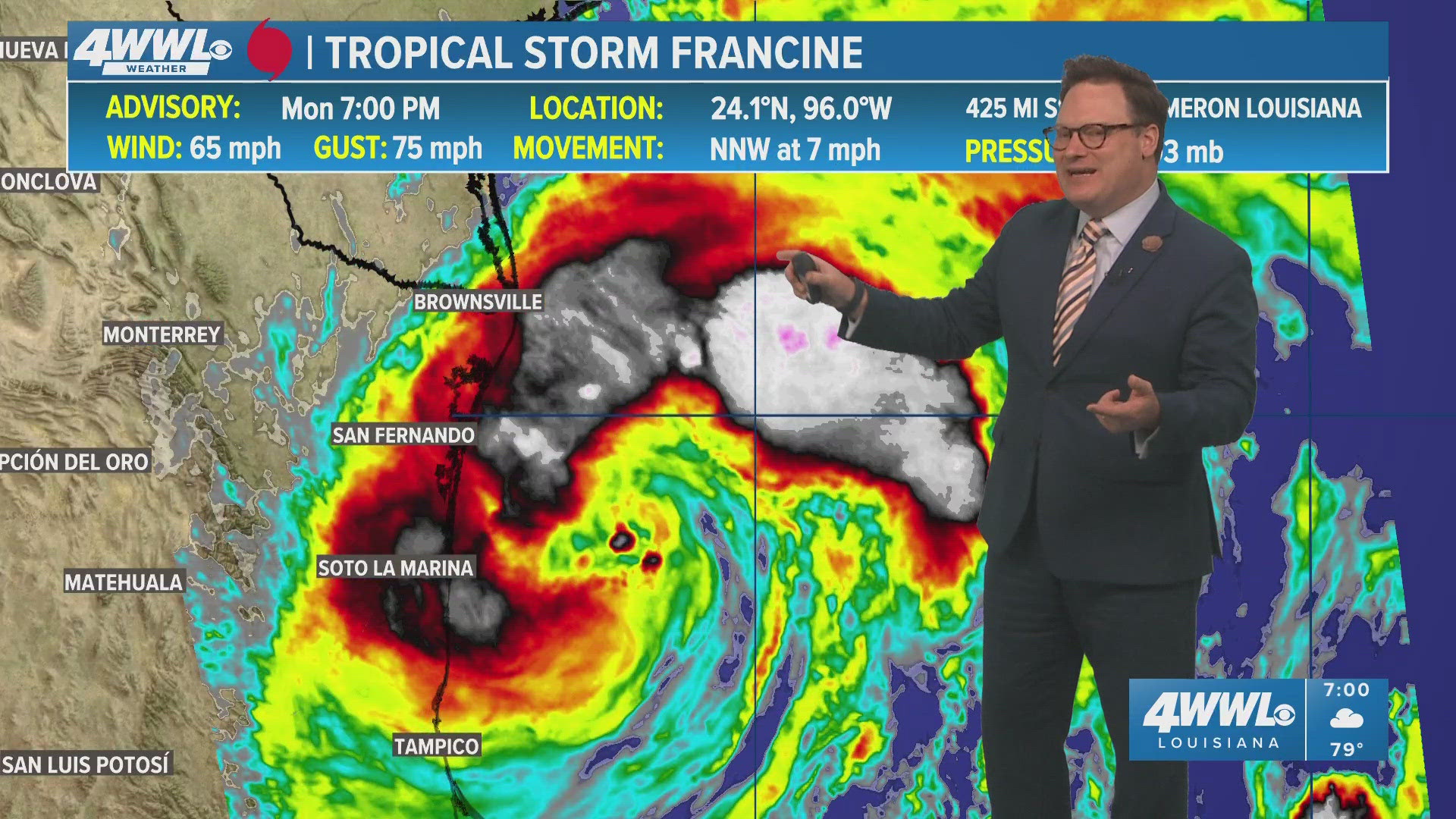
Monday 7 PM – Latest tracking of Tropical Storm Francine
WWL Louisiana Chief Meteorologist Chris Franklin with the latest developments on Tropical Storm Francine and potential impact to southeast Louisiana.
Monday 5 PM – Jefferson Parish press conference on Francine preparations
Jefferson Parish President Cynthia Lee Sheng joins other parish officials for a press conference on Tropical Storm Francine preparations.
Flood Gates and boat launch to close ahead of TS Francine
The Sellers Canal Sector Gate and Paradis Gate will close at 8 a.m. on Tuesday due to Tropical Storm Francine.
The Des Allemands Boat Launch under the US Highway 90 Bridge will close at 4 p.m. on Tuesday.
Mandatory evacuation issued, Terrebonne & Plaquemines parishes
Terrebonne Parish Consolidated Government issued a mandatory evacuation for Zone 1 starting immediately. Residents must be out by 6 a.m. on Wednesday.


Plaquemines Parish officials also issued a mandatory evacuation for the following areas: Lake Hermitage, Happy Jack, Myrtle Grove, Tidewater Rd., Venice, White Ditch to Phoenix, Woodpark, Grand Bayou.
Evacuations are to begin by Tuesday at 7 a.m.
Voluntary evacuation for the following areas by 2 p.m. include all of Eastbank and Venice North to Alliance.
Temporary Shelter Information:
• Location: PPG Multipurpose Center
• Opening: Tuesday at noon
• Conditions: Shelter and water only; please bring all essentials and medications.
Need Transportation?
• Contact Community Action at (504) 934-6940
Monday 4:30 PM – Gov. Landry issues 'statewide emergency declaration'
Louisiana Governor Jeff Landry hosts press conference on storm preparedness along with LANG, LSP, GOHSEP and Insurance Commissioner Tim Temple.

“This State of Emergency will allow parishes statewide to have the resources to help protect the life, safety, and welfare of the citizens of Louisiana," said Gov. Landry. "Throughout this process, we will remain in constant contact with local officals and first responders and will assist them in every step of the way."
Monday 4 PM – Update shows stronger Francine at landfall. Slight jog to the west and faster storm making landfall earlier.
Tropical storm warning, tropical storm watch and hurricane watch issuesd for parts of Louisiana.
Monday 3:30 PM – City of New Orleans announces prep for Francine
Mayor LaToya Cantrell, New Orleans Homeland Security and Emergency Preparedness (NOHSEP) & local leaders provide Tropical Storm Francine prep updates.

Monday 2:40 PM – City of Thibodaux declares Emergency Declaration
Mayor Clement signed an Emergency Declaration in anticipation of Tropical Storm Francine. "This declaration will ensure that the City will have proper access to many resources that may be needed to respond to this event," the city of Thibodaux said.
Monday 1:45 PM – Terrebonne Parish School Closings
TPSO schools announced that they will be closed Wednesday, September 11, and Thursday, September 12, due to weather conditions from Francine.
Monday 1 PM – FEMA urges residents in Francine's path to prepare
Here are some tips from FEMA:
Stay informed. People in these areas should continue to follow the instructions of state and local officials by monitoring local radio or television stations for updated emergency information.
Have a plan. Make sure you consider your family’s unique needs, including anyone who needs medicine or medical equipment. Visit Ready.gov or Listo.gov (Spanish language) for more information on how to stay safe before, during and after severe weather.
Know how to stay safe during high winds, storm surge and flooding. Determine how best to protect yourself from high winds and flooding. Evacuate immediately if you are told to do so.
Be in the know about your evacuation route. Learn more about how to evacuate safely on Ready.gov and Listo.gov (Spanish language).
Monday 12:38 PM – Grand Isle calls for voluntary evacuation
Mayor David Camardelle called for a voluntary evacuation as of 11 a.m. on Monday. A mandatory evacuation was issued for campers/rv's, cargo and boat trailers.
Grand Isle school is also canceled on Tuesday.
Monday 11:30 AM – FLOOD WATCH issued for Southeast Louisiana
Bookmark this page and check back often for the latest info.
► Get breaking news from your neighborhood delivered directly to you by downloading the new FREE WWL-TV News app now in the IOS App Store or Google Play.