
NEW ORLEANS — Here are the expected impacts from Hurricane Francine on different parishes.
Most impacts will be felt Wednesday into Wednesday night. These threats are based on the current forecast and could change. Check back frequently.
New Orleans Metro
(Orleans, Upper Jefferson, Upper St. Bernard, Upper Plaquemines)
- Wind: 30-40 mph, gusts to 50-70 mph
- Storm surge: 4-6 feet for Lake Pontchartrain.
- Storm Surge: 4-6’ feet outside hurricane protection levee in Orleans
- Rainfall: Around 3-6"
- Few tornadoes possible
St. Tammany
- Wind: 30-40 mph, gusts to 50-70+ mph
- Storm surge: 4-6 feet for Lake Pontchartrain
- Rainfall: Around 3-6" isolated 8-12'' possible
- Few tornadoes possible
Lower Plaquemines & East St. Bernard
- Wind: 40-50 mph, gusts to 60-80 mph
- Storm surge: 4-7’ feet west bank of river, 3-5’ feet east bank of river
- Rainfall: Around 3-6"
- Few tornadoes possible
Lower Jefferson
- Wind: 40-50 mph, gusts to 50-70 mph
- Storm surge: 4-7 feet
- Rainfall: Around 3-6"
- Few tornadoes possible
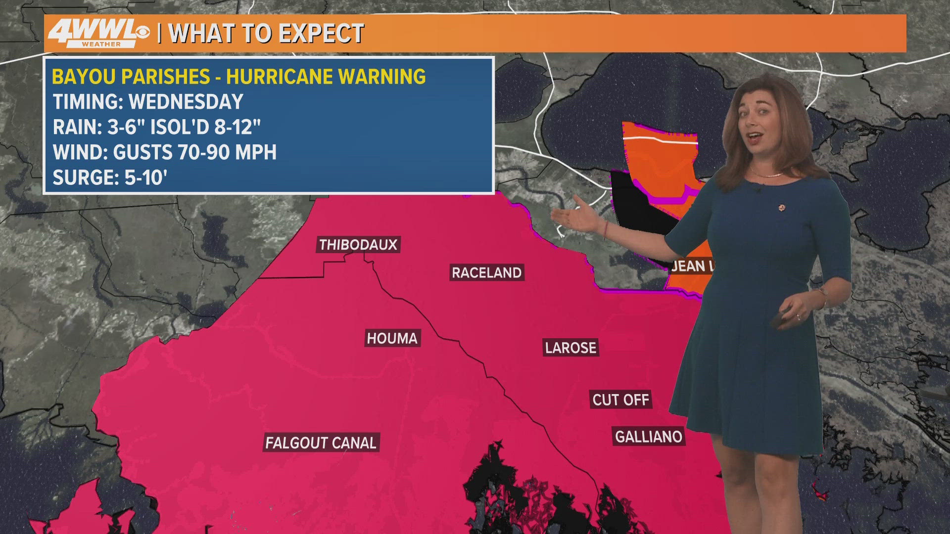
Terrebonne & Lafourche
- Wind: 40-60 mph gusts to 70-90 mph
- Storm surge: 5-10 feet
- Rainfall: Around 3-6"
- Few tornadoes possible
St. Charles, St. James, St. John, Assumption
- Wind: 40-50 gusts to 60-80 mph
- Storm surge: 3-5 feet for Lake Pontchartrain and 3-5 Lake Maurepas
- Rainfall: Around 3-6”
- Few tornadoes possible
Hancock and Pearl River counties, MS
- Wind: 25-35 mph, gusts 40-50 mph
- Storm surge: 2-4 feet
- Rainfall: Around 1-3"
- Few tornadoes possible
Washington
- Wind: 25-35 mph, gusts 40-50 mph
- Rainfall: 3-6"
- Few tornadoes possible
Tangipahoa
- Wind: 35-45, gusts 50-70 mph
- Storm surge: 2-4 feet for Lake Pontchartrain and 2-4 feet Lake Maurepas
- Rainfall: 3-6 "
- Few tornadoes possible