

NEW ORLEANS — If you’re evacuating from Hurricane Ida, some of the cities you’d usually consider may not be safe from the storm.
Chief Meteorologist Chris Franklin laid out how far the strong winds and heavy rain from Hurricane Ida could reach and how far you’ll have to go to make sure you avoid them.
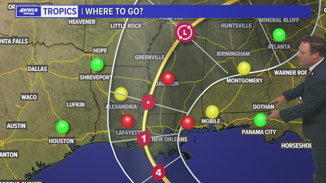
According to Franklin, the Mississippi coast, Jackson, MS and Lafayette are all in Hurricane Ida’s cone and aren’t far enough away to avoid the severe storm.
To the west, Alexandria is safer because it’s on the “dry side” of Hurricane Ida, but you’d still be better off going all the way to Shreveport or Houston.
If you’re going east, Mobile and Montgomery are likely far away enough to miss the worst of the storm, but you’d be better off going all the way to Panama City or Atlanta.
If you need a shelter to evacuate to, call 211 or text LAShelter to 898211 for state shelter information.

Should I evacuate?
As for if you should evacuate, there are a few questions you should consider.
If you’re not, do you live somewhere that won’t flood? Storm surge could reach 10-15 feet Sunday evening. The lakes could experience a 4-7 feet rise. Heavy rain will also be a threat with some areas seeing more than 10 inches of rain.
If you’re in a flood-prone area and your home isn’t raised, you should consider evacuating.
Do you have an alternate source of power or are you OK with not having power for a long time?
Large parts of Louisiana will likely lose power for several days, possible weeks or even a month due to Hurricane Ida. If you need power for medical devices or anything else that you need to survive, you should leave.
Do you feel comfortable staying for the storm? If your gut is telling you to leave, then it’s time to leave.
Hurricane Ida is a Cat. 4 storm as of Friday afternoon and is still getting stronger. The National Hurricane Center forecasts the storm making landfall in southeast Louisiana on Sunday afternoon to evening as a Category 4 hurricane with winds of 140 mph.
Wind, rain, and storm surge will all be threats. We are expecting conditions to worsen late Saturday and throughout Sunday. Prepare now.