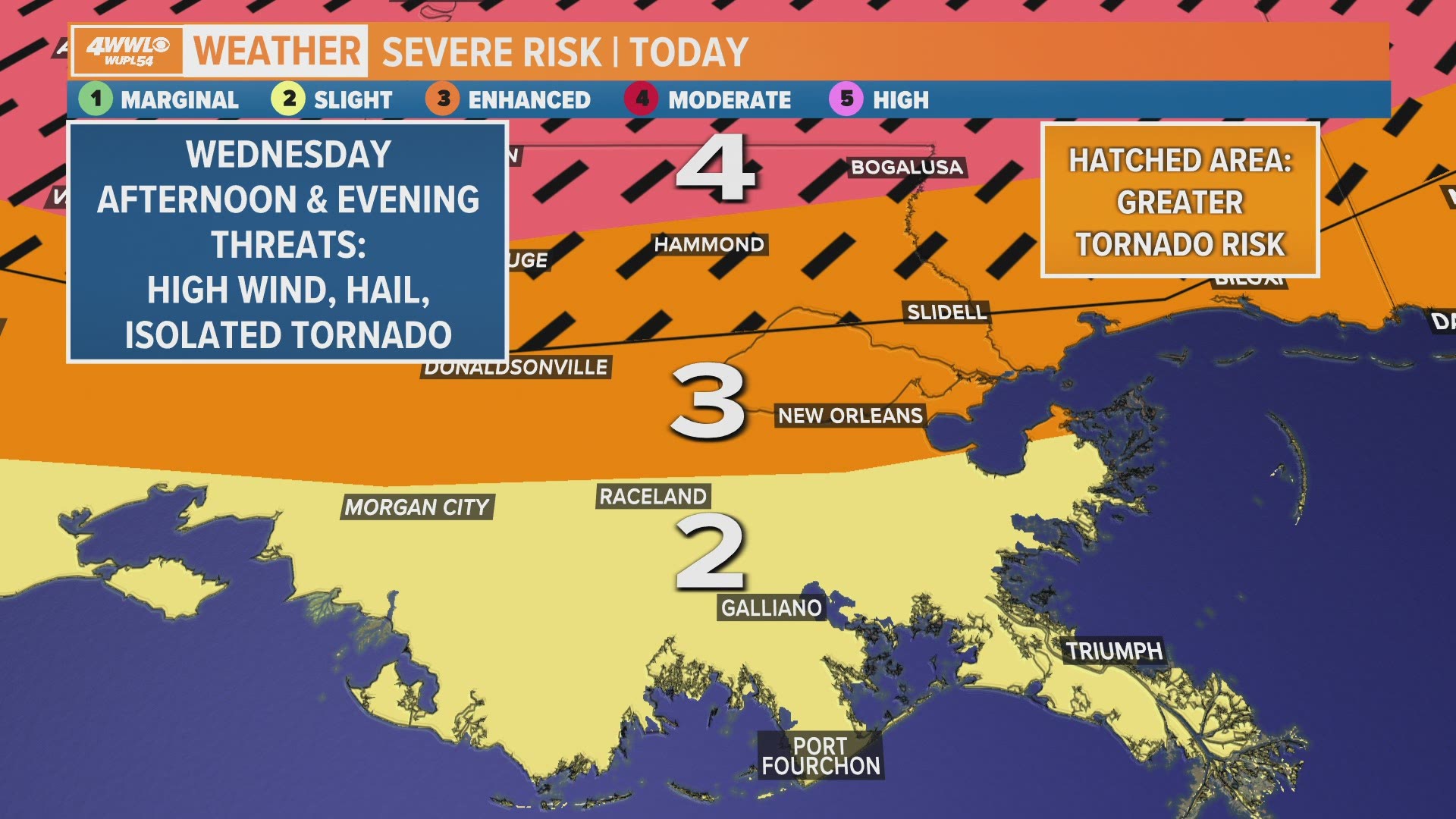
NEW ORLEANS — An 'enhanced' risk of severe weather is outlined for the New Orleans area and Northshore for Wednesday from late afternoon through evening.
Damaging wind gusts, large hail and isolated tornadoes will all be possible, especially with a line of storms which is expected around 8 p.m.
Here's what to expect in your area as the storm rolls through:
New Orleans metro - Orleans and upper Jefferson
Severe risk: Enhanced (level 3 of 5 – numerous severe storms possible)
Timing: Wednesday late afternoon and evening, especially 8-11 p.m.
Threats: Damaging winds, large hail, isolated tornadoes
Wind: 25-35 mph, gusts to 45+ mph
Rainfall: .5-1"
St. Bernard
Severe risk: Enhanced (level 3 of 5 – numerous severe storms possible)
Timing: Wednesday late afternoon and evening, especially 9-11 p.m.
Threats: Damaging winds, large hail, isolated tornadoes
Wind: 25-35 mph, gusts to 45+ mph
Rainfall: .5-1"
Plaquemines
Severe risk: Slight (level 2 of 5 – scattered severe storms possible)
Timing: Wednesday late afternoon and evening, especially 10 p.m. to midnight
Threats: Damaging winds, large hail, isolated tornadoes
Wind: 25-35 mph, gusts to 45+ mph
Rainfall: .5-1"
Lafourche and lower Jefferson
Severe risk: Slight (level 2 of 5 – scattered severe storms possible)
Timing: Wednesday late afternoon and evening, especially 7-10 p.m.
Threats: Damaging winds, large hail, isolated tornadoes
Wind: 25-35 mph, gusts to 45+ mph
Rainfall: .5-1"
Terrebonne
Severe risk: Slight (level 2 of 5 – scattered severe storms possible)
Timing: Wednesday late afternoon and evening, especially 7-10 p.m.
Threats: Damaging winds, large hail, isolated tornadoes
Wind: 25-35 mph, gusts to 45+ mph
Rainfall: .5-1"
St. Charles, St. James, St. John, Assumption
Severe risk: Enhanced (level 3 of 5 – numerous severe storms possible)
Timing: Wednesday late afternoon and evening, especially 7-10 p.m.
Threats: Damaging winds, large hail, isolated tornadoes
Wind: 25-35 mph, gusts to 45+ mph
Rainfall: .5-1"
St. Tammany, southern Tangipahoa and southern Washington
Severe risk: Enhanced (level 3 of 5 – numerous severe storms possible)
Timing: Wednesday late afternoon and evening, especially 8-11 p.m.
Threats: Damaging winds, large hail, elevated tornado risk
Wind: 25-35 mph, gusts to 45+ mph
Rainfall: .5-1"
Northern Washington and Tangipahoa
Severe risk: Moderate (level 4 of 5, widespread severe storms likey)
Timing: Wednesday late afternoon and evening, especially 7-11 p.m.
Threats: Damaging winds, large hail, elevated tornado risk
Wind: 25-35 mph, gusts to 45+ mph
Rainfall: .5-1"
Hancock, MS
Severe risk: Enhanced (level 3 of 5 – numerous severe storms possible)
Timing: Wednesday late afternoon and evening, especially 10 p.m. to midnight
Threats: Damaging winds, large hail, elevated tornado risk
Wind: 25-35 mph, gusts to 45+ mph
Rainfall: .5-1"
Pearl River, MS
Severe risk: Moderate (level 4 of 5, widespread severe storms likely)
Timing: Wednesday late afternoon and evening, especially 10 p.m. to midnight
Threats: Damaging winds, large hail, isolated tornadoes
Wind: 25-35 mph, gusts to 45+ mph
Rainfall: .5-1"
More Stories:
► Get breaking news from your neighborhood delivered directly to you by downloading the new FREE WWL-TV News app now in the IOS App Store or Google Play.

