

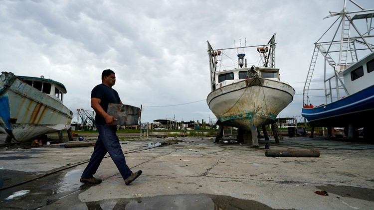
NEW ORLEANS — Louisiana is dealing with a rare double-threat from two storms in the Gulf of Mexico.
Hurricane Marco is headed north through the Gulf towards the Louisiana coast, while Tropical Storm Laura is headed northwest on a track for Louisiana or Texas as a possible Category 2 hurricane.
Complicating matters is the coronavirus, which makes it difficult for evacuation orders to be issued and puts more people in danger as they come together to ride out the storm.
Here are the latest updates from around Southeast Louisiana as the storms impact the state:
1:55 PM Monday
Kenner announces city offices to be open Tuesday, garbage collection to resume.
1:45 PM Monday
Terrebonne announces curfew lifted for Monday and Tuesday nights. Still in place for Wednesday night from 10 pm until 6 pm in anticipation of Laura.
1:20 PM Monday
Jefferson Parish will resume trash, recycling and waste collection on Tuesday, Aug. 25. There will be no makeup day for Monday's missed collections.
1 PM Monday
Marco is barely a tropical storm, with sustained winds of 40 mph as it continues to crawl towards the mouth of the Mississippi River at about 6 mph.
Tropical force winds bottom out at 39 mph, meaning if Marco becomes much weaker, it will be a simple tropical depression by the time it makes landfall on the Louisiana coast.
Some showers from the deteriorating storm are passing over the eastern part of southeast Louisiana, bringing a small amount of rain.
Heavier rain is expected around 7:30 p.m. with the heaviest downpours expected around 2 a.m.
The tropical storm warning for Marco across southeast Louisiana has expired as of the 1 p.m. tropics update.
12:36 PM Monday
Mayor LaToya Cantrell emphasized caution, even as a weakened Tropical Storm Marco slowly rolls closer to Louisiana.
Laurel, the other Gulf storm, is close behind and is projected to have possible rain and wind impacts on the city of New Orleans.
City-owned vehicles have been placed on high ground ahead of the storms, she said.
Government buildings will be open for service Tuesday because the forecast for tomorrow is "non-threatening," Cantrell said. That includes City Hall.
12:18 PM Monday
Some flights out of MSY have been canceled ahead of Tropical Storm Marco. The airport said on Twitter that it would remain open as long as it was safe to do so.
All Southwest flights after 3 p.m. Monday were canceled, as well as some early-morning Tuesday flights.
Officials encouraged passengers to check in with their airlines for up-to-date flight information as there may be unexpected changes because of the storm.
Noon Monday
Tropical Storm Marco will likely make landfall near St. Bernard Parish later Monday night. Ahead of the storm, which is rapidly weakening, it's a mostly dry Monday.
Some downpours are expected around the southeast Louisiana area by 7 p.m. but heavier rain isn't expected until overnight, around 2 a.m.
11:40 AM Monday
Gov. John Bel Edwards said that more than 1,300 inmates have been evacuated from Plaquemines, St. Mary, Terrebonne and Vermilion parishes ahead of Laura, which is projected to be a hurricane by the time it makes a Louisiana landfall.
11:30 AM Monday
Gov. John Bel Edwards said Louisiana caught "a big break" with Tropical Storm Marco after it rapidly lost steam ahead of a projected landfall.
The biggest threat, the governor said, is Laura, which is projected to be a hurricane when it reached Louisiana's coast.
The heaviest impacts will likely be from Morgan City west, Edwards said. Impacts from Laura are likely east of the city, but won't be nearly as pronounced.
The conditions in the Gulf are favorable for Laura to strengthen into a Category 1, 2 or possibly Category 3 hurricane by the time it reaches the U.S. shores.
10:50 AM Monday
The metro New Orleans area could see less rain than earlier anticipated, according to the latest forecasts of Tropical Storm Marco's path.
The storm, which weakened from a hurricane yesterday, has struggled to maintain form. Current models have it curving over land and heading west across Louisiana as it loses power.
10:30 AM Monday
St. Tammany Parish President Mike Cooper warned residents not to let their guard down ahead of two storms set to hit Louisiana in the coming days.
"There are still many uncertainties about these storms," Cooper said. "Every update we get...changes the course, changes the intensity and changes the landfall of these storms."
Parish government buildings such as administrative offices, schools and libraries are all closed in anticipation of the storms.
10 AM Monday
Tropical Storm Marco is slowing down to 8 mph as it slowly moved towards Louisiana. The storm has lost power through the Gulf, and will likely only be a rainmaker for the metro New Orleans area.
The track for the storm has pushed north, meaning forecasts have the center of the storm traveling over land across Louisiana. Previous tracks have shown it skirting the southern coast towards Texas.
9:32 AM Monday
When life gives you a waiting game...play another. As New Orleans braces for rain from Tropical Storm Marco, at least one golfer on the lakefront is practicing his drive.
9:15 AM Monday
With two storms coming in, local power companies say that if you lose power, it may take longer to restore service due to delays in dispatching equipment and crews.
Entergy and Cleco have dispatched emergency crews, but say if power is knocked out by either storm, conditions could hamper their ability to access downed power lines and other damaged equipment.
8:45 AM Monday
A handful of people are continuing to fill sandbags in Plaquemines Parish ahead of Tropical Storm Marco and Laura, which is projected to be a hurricane when it makes landfall.
At one sandbag station, blue skies could be seen overhead and a pleasant breeze kept the few late preppers from the heat.
8:26 AM Monday
Tangipahoa Parish President Robby Miller says the parish is in a good place for Laura after making early preparations fro Tropical Storm Marco.
While there are no plans for an emergency shelter in the parish, Miller said emergency crews were ready and would be able to set one up in less than two hours if needed.
"For the most part, we're in good shape," he said.
The one concern he cited, speaking on-air with WWL-TV is that rainwater and storm surge from Marco won't be able to drain fast enough because of the way winds are blowing. If that is the case, Laura could compound the problem when it arrives as a hurricane Wednesday or Thursday.
8:18 AM Monday
Rainfall along the Louisiana coast is expected to be the heaviest impact from Tropical Storm Marco. Current forecasts indicate anywhere from 3-6 inches of rain will fall along the coastal parishes before Marco falls apart.
7:53 AM Monday
About 50 people are sheltering at the emergency center in Belle Chase Monday ahead of twin storms Marco and Laura.
Areas in Plaquemines Parish not protected by levees are under mandatory evacuation orders, and the 50 people in Belle Chase are among the 75% of people who have already left their homes ahead of the storms.
7:31 AM Monday
According to the National Weather Service, Tropical Storm Marco is significantly weaker Monday than it was Sunday, about 85 miles south of the moth of the Mississippi River.
Rainfall of 3-5 inches is expected in some areas, and areas prone to flooding may see several inches of standing water.
Lake Pontchartrain will see 2-3 feet of storm surge.
7:08 AM Monday
Tropical Storm Laura is over water off the southern coast of Cuba, allowing it to strengthen as it passes northwest towards the Gulf.
It is predicted to be a Category 2 hurricane at landfall, with the possibility of being a Category 3 storm when it strikes the coast.
If it does intensify to a Cat 3, It will be the first time since Hurricane Rita 15 years ago that Louisiana has been hit by a storm that powerful.
The storm is being helped along by high water temperatures and favorable air conditions. It is expected to make landfall Wednesday.
6:40 AM Monday
Rain has begun falling on Grand Isle. The island on the southern tip of Jefferson Parish is usually one of the first places in Louisiana to feel the effects of tropical storms and hurricanes.
Outer bands of rain from Tropical Storm Marco are expected to pass over southeast Louisiana Monday as the storm makes its way closer to the coast.
Current projections have the storm following the coast west, possibly not making a traditional landfall.
6:30 AM Monday
It's a normal storm drill for New Orleans Monday morning. Cars are parked on the neutral ground across the city, especially in flooding-prone areas like those near Claiborne Avenue and Jefferson Avenue.
While tropical-storm-force winds are likely to largely miss the New Orleans metro area, Tropical Storm Marco and possible hurricane Laura behind it are forecasted to be major rainmakers for the city over the workweek.
6:10 AM Monday
Workers were evacuated from more than 100 oil and gas platforms in the Gulf of Mexico ahead of Marco and Laura.
The Interior Department said Sunday that 58% of oil production and 45% of natural gas production in the Gulf was shut down by the storms.
The shutdowns are usually temporary as long as platforms aren't seriously damaged, and experts say oil and gas prices aren't likely to change much because of them.
The Gulf of Mexico accounts for just under 20% of all U.S. oil production.
5:55 AM Monday
Hot air is keeping Marco from maintaining stength as it continues it's trek towards Louisiana's coast. The tropical storm system's thunderstorms are being pushed north and away from the center by a trough of warm, dry air passing into the gulf from over Texas and Mexico.
But that buffer is set to retreat back west over land almost as soon as Marco passes through, meaning that Laura, which is still gathering strength off the southern coast of Cuba, won't have to fight it on its way through the Gulf.
That's why Marco was barely able to form up into a Category 1 hurricane and weakened back to a tropical storm overnight, while meteorologists predict Laura will strengthen possibly into a Category 2 hurricane with winds over 100 mph by landfall.
5:20 AM Monday
Tropical Storm Marco will not produce any hurricane warnings for Louisiana, effectively ending the possibility that the storm will strengthen again.
All hurricane warnings for the state have been canceled, with tropical storm warnings remaining for most of southeast Louisiana and the Mississippi coast.
Marco is expected to make landfall and hug the coast by Monday night, with rain from the lopsided storm hitting the metro New Orleans area sometime in the late morning or afternoon.
4:50 AM Monday
Tropical Storm Marco is approaching Louisiana for an expected landfall around midday Monday. Marco was a hurricane most of Sunday, but the National Hurricane Center says its maximum sustained winds decreased after nightfall. The center cautions that Marco could still cause life-threatening storm surges and dangerous winds along the Gulf Coast.
11:30 p.m. Sunday
Crews in St. Bernard Parish began closing flood gates early Sunday morning and they expect to have 57 floodgates closed by midnight Sunday.
Erika Ferrando reports.
11:00 p.m. Sunday
In Grand Isle, a curfew is in place tonight for anyone choosing to stay during the storm. The mayor issued a mandatory evacuation order for the island this morning. As Thanh Truong reports, people living along coastal Louisiana are uneasy about the next few days.
10:00 p.m. Sunday
The forecast track hasn't changed much, but it's unclear if Marco's path will actually hit the Lousiana coast or continue west before making it onto land.
The Louisiana coast may still experience some tropical weather next week, so residents should stay vigilant in their preparations.
6:15 p.m. Sunday
During a press conference on Louisiana's preparation for Hurricane Marco and Tropical Storm Laura, Gov. John Bel Edwards said residents should be prepared to shelter in place for 72 hours, there will only be 12-18 hours in between storms for search and rescue and recovery operations.
All state-run COVID-19 testing sites will be closed Monday and Tuesday
Edwards also urged Louisianans to practice COVID-19 precautionary measures — like wearing a mask — when dealing with people outside of the immediate family.
5:18 p.m. Sunday
All Jefferson Transit public transportation services will be suspended Monday ahead of Hurricane Marco and Tropical Storm Laura, a release said.
5 p.m. Sunday
Activating the Kenner's Emergency Operation Center, Mayor Ben Zahn declared a state of emergency Sunday in anticipation of Hurrican Marco and Tropical Storm Laura, ordering all Kenner city offices to remain closed Monday.
The mayor also ordered the activation of a City Help Line to answer non-emergency, weather-related questions and to take information about any reports of damage from Hurricane Marco.
The Help Line number is (504) 468-4357 (HELP). However, any resident with an emergency should call 911.
4:52 p.m. Sunday
Jefferson Parish cancels mobile COVID-19 testing for Monday and Tuesday.
4 p.m. Sunday
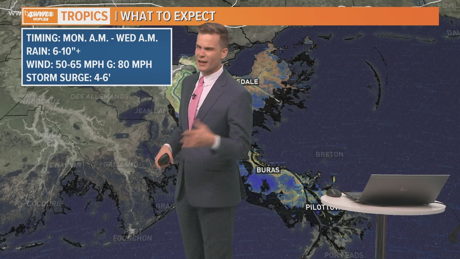
The latest Hurricane Marco track forecasts show expected landfall shifting west, leaving the New Orleans area on the wetter side of the storm. Marco impacts Monday are forecast to include 3-6 or more inches of rain, high winds with gusts of up to 80 mph, possible tornadoes and more.
3:58 p.m.
The USPS is closing post offices in Southeast Louisiana on Monday because of Hurricane Marco. All post offices in zip codes beginning in 700xx, 701xx, 703xx, 704xx, 707xx and 708xx will be closed.
Post offices are scheduled to continue normal work hours Tuesday.
3:23 p.m. Sunday
In preparation for Hurrican Marco and Tropical Storm Laura, the New Orleans Regional Transit Authority's entire public transportation system will be shut down 2 a.m. Monday
Streetcar services are scheduled to be suspended 4 p.m. Sunday, but bus service will replace the suspended lines until the system-wide closure:
- Bus route #47 - Canal-Cemeteries-Loyola Streetcar Lines
- Bus route #48 - Canal-City Park Streetcar Line
- Bus route #12 - St. Charles Streetcar Line
- Bus routes #5 and #55 - Riverfront Streetcar Line
The ferry service will remain suspended until further notice. The Algiers Point – Canal St. bus shuttle will continue operating to provide terminal-to-terminal service.
2:35 p.m. Sunday
President Donald Trump has approved Louisiana's emergency declaration, making federal funds available to state, local, tribal and territorial governments responding to the threat of the two storms headed towards the U.S.
The emergency disaster declaration was issued by Gov. John Bel Edwards ahead of the arrival of Hurricane Marco and Tropical Storm Laura, which is expected to become a Category 3 hurricane by landfall.
2:26 p.m. Sunday
City Hall is closed Monday because of Hurricane Marco, New Orleans officials announced Sunday.
The announcement didn't say anything about Tuesday closures, but warned that Tropical Storm Laura was expected to hit Wednesday or Thursday, bringing more rain and wind to the city.
Laura is expected to be at least a Category 2 hurricane by the time it reaches the U.S. Coast.
1:42 p.m. Sunday
COVID-19 testing sites in and around New Orleans will be closed as Marco and Laura make their way through Louisiana, officials announced Sunday.
The testing sites run by UnitedHealth Group at City of Love Church in Gert Town and St. Mary of the Angels in the Ninth Ward will be closed from Aug. 25-Aug. 29.
Ochsner testing sites in Gretna, Livingston and LaPlace have all been temporarily shut down ahead of the storms. They are expected to resume operation Thursday.
1:31 p.m. Sunday
Several noteworthy areas in New Orleans will be closed through at least Tuesday as officials prepare for the impact of Hurricane Marco.
The Audubon Zoo and Audubon Aquarium will both be closed Monday and Tuesday (although both are regularly scheduled to be closed Tuesday). They are currently set to resume operations Wednesday morning.
City Park will also be closed, with certain parts of the park closing throughout Sunday, with the full park closed Monday. The closure will last through at least Tuesday, but could last into Wednesday and beyond, city officials said.
1:06 p.m. Sunday
A boil water advisory has been issued for the Lower Ninth Ward and a portion of the Upper Ninth Ward Sunday.
Residents in the area are advised to use bottled or boiled tap water to cook, clean or brush teeth.
The advisory comes ahead of a hurricane, which could complicate the ability of crews to fix the water pressure, which dipped during planned valve work. Boil water advisories last for at least 24 hours because of the length of time it takes to fix them and for samples to be sent for contaminant testing.
1 p.m. Sunday
Hurricane Marco will likely not become stronger than a Category 1 storm as it treks north across the Gulf, because a buffer of warm, dry air to the west will prevent it from gathering strength and moisture.
Laura's path continues to be uncertain because the storm is headed over the entirety of Cuba, throwing a wrench into the usual meteorological prediction methods.
12:56 p.m. Sunday
Trash pickup on Monday and Tuesday has been canceled for St. Bernard Parish because of Hurricane Marco, parish officials said Sunday.
Residents should bring their garbage bins inside or secure them somewhere they won't become projectiles if picked up by the wind.
Curbside pickup will begin once weather conditions improve.
12:50 p.m. Sunday
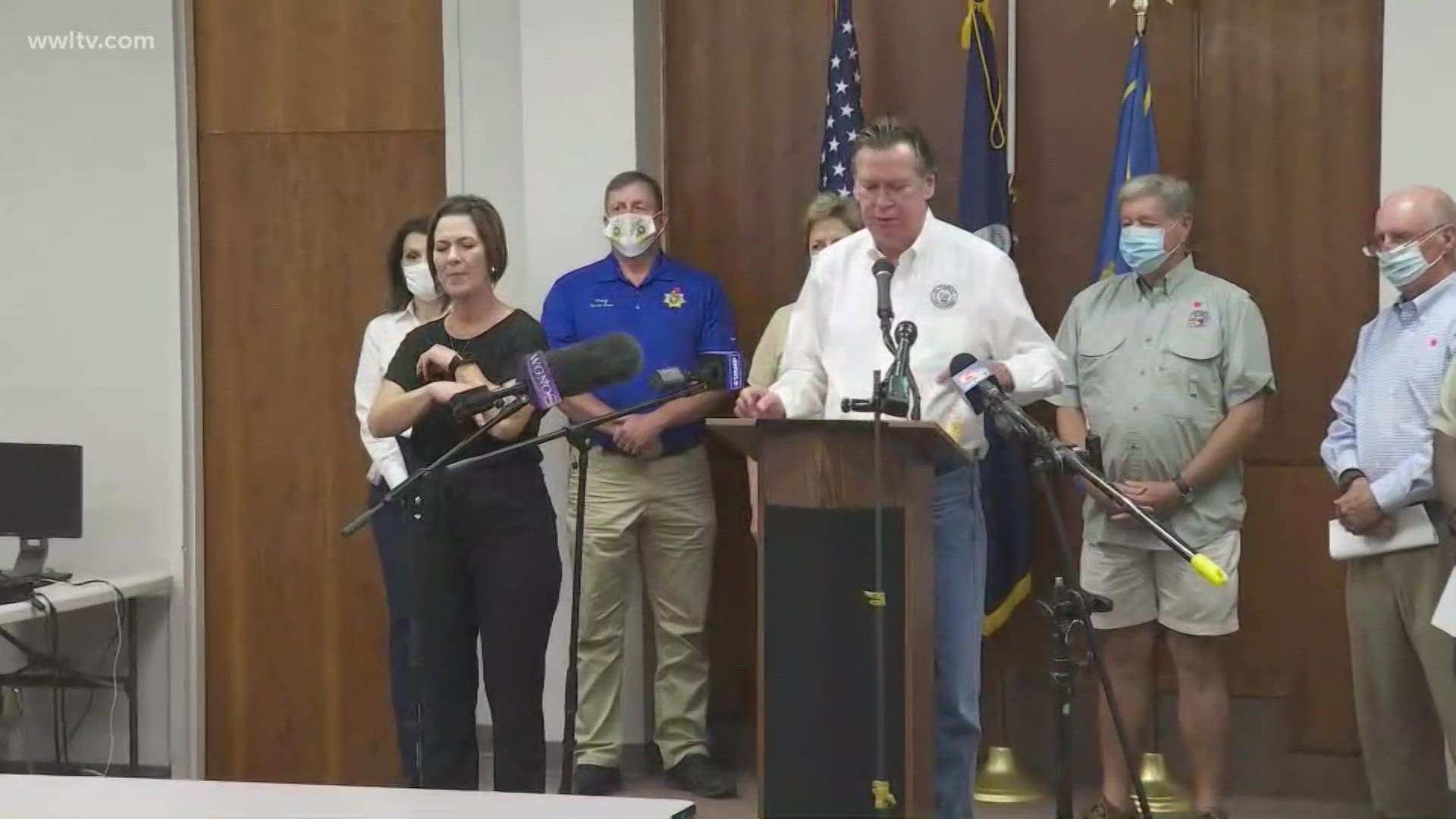
Gov. John Bel Edwards laid out the government's preparations for Laura and Marco ahead of Marco's arrival in the state as a hurricane.
He said 17 parishes have already declared emergency orders and that more than a dozen more were preparing to do so.
Another update from Edwards is expected at 6 p.m.

12:35 p.m. Sunday
The New Orleans Sewerage & Water Board said Sunday ahead of Hurricane Marco's arrival that all 99 drainage pumps in the city are online and ready for rain.
Four of the utility's power-generating turbines are online, as well as five "electro-motive diesel" generators and five frequency changers to convert the power to one useable by the city's antiquated pump infrastructure.
S&WB officials emphasized that the drainage system's age means it is vulnerable to storm-related challenges, including generators or turbines going down.
Residents in low-lying areas of the city should prepare for street flooding.
12:30 p.m. Sunday
Hurricane Marco is swirling over the Gulf of Mexico, expected to bring storm surge and hurricane-force winds to Louisiana on Monday.
Meanwhile, Tropical Storm Laura has knocked utilities out as it batters Hispaniola, following a track forecast to take it to the same part of the U.S. coast later in the week, also as a hurricane.
It could be the first time two hurricanes appear in the Gulf of Mexico simultaneously, according to records dating to at least 1900.
Here is the full press conference from St. Tammany Parish ahead of the storm:
More Stories:
► Get breaking news from your neighborhood delivered directly to you by downloading the new FREE WWL-TV News app now in the IOS App Store or Google Play.