NEW ORLEANS —
Tropical Storm Delta
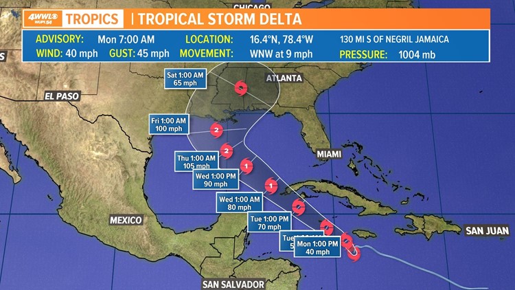
On Monday morning, Tropical Storm Delta formed. The forecast path has it entering the Gulf of Mexico Tuesday night or Wednesday as a hurricane.
Impacts including rain, wind and coastal flooding look likely for parts of the Gulf Coast on Thursday and Friday - but there is still uncertainty in exact impacts and locations since the system is far out.
The National Hurricane Center's average error for the location of a system five days out is 200 miles, so the longer-range part of the forecast could easily shift east or west. Right now the center line crosses over southeast Louisiana and shifted slightly westward since the depression formed Sunday night, but model solutions range from far east Texas to the Florida Panhandle.
While there is uncertainty in the eventual path and intensity of the system, the current National Hurricane Center forecast has it reaching hurricane strength on Tuesday and perhaps strengthening to a Category 2 storm by Thursday. Eventually, cooler waters near the Gulf Coast plus increasing wind shear should cap its strengthening potential.
Right now any impacts for south Louisiana would likely happen Thursday and Friday - but again, it's difficult to say how intense any impacts will be this far out. Rainfall of 2-5+ inches, along with coastal flooding and strong winds look likely in that timeframe if the system takes the current forecast path.
Steering factors for the storm include high pressure over the western Atlantic which will start to build farther east to keep the system moving northwest. Its eventual turn to the north and northeast will be due to a trough of low pressure and surface front that will settle over the region late in the week. When the system encounters the trough and surface front, it should pull to the northeast.
The path may go a little more west if Tropical Storm Gamma stays somewhat strong and exerts a pulling influence over soon-to-be Delta. A more westward track would likely bring more intense impacts to south Louisiana since it would place us on the wetter east side of the center.
A lot depends on the timing of the trough, along with the strength of Tropical Storm Gamma, plus a few other factors, plus the exact position of the storm when it reaches the Gulf. Until we see these things take shape, we'll have some uncertainty.
Many more updates will be coming.
GAMMA
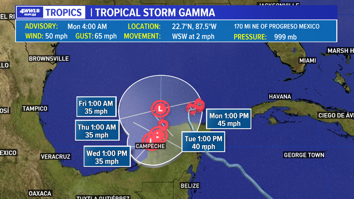
Tropical Storm Gamma's winds are weaker early Monday morning at 50 mph as dry air gets wrapped into the slowly moving system. The center was in the southern Gulf, and it is expected to drift to the west and south generally over the next few days as a ridge of high pressure builds ahead of the system.


Gamma should hang in the southern Gulf through late week and eventually weaken. It will not directly affect Louisiana, but its presence may exert some influence on Delta once that system enters the Gulf midweek. A weaker Gamma could be a good thing for south Louisiana since it would exert less of a westward pull and could allow soon-to-be Delta to stay farther east of us.
There is still much uncertainty in how much influence Gamma will have. More updates will be coming.
HURRICANE CENTER: Latest Tracks, Models & Radar - Click here.
► Track the tropics with live updates delivered directly to your phone. Text APP to 504-529-4444 to download the FREE WWL-TV News app now or find us in the iOS App Store or Google Play.
► Track the tropics, live updates from Your Local Weather Experts delivered directly to you throughout hurricane season by downloading the FREE WWL-TV News app now in the IOS App Store or Google Play.


