NEW ORLEANS — As the peak of hurricane season is just getting underway, the 2024 Atlantic season so far has not been off the charts.
Earlier this season, Colorado State University and the National Oceanic and Atmospheric Administration issued their forecasts calling for a well above-average season. Though August has been quiet thus far, it may soon turn active as historically tropical activity ramps up tremendously from now through early October.
So why has the season been slow to go so far?
Initially, a developing La Nina pattern was one of the biggest contributors to the hyperactive early season forecasts. La Nina supports lower wind shear in the Atlantic Basin, hence tropical storms and hurricanes are more likely to develop.
However, La Nina has been taking its time and is not expected to arrive until the upcoming winter months.
Additionally, you may have seen videos online about the ITCZ being situated farther north, an active Saharan dust season, and the Madden Julian Oscillation not taking shape as projected in this part of the world as contributing factors as to why the season is off to a slow start.
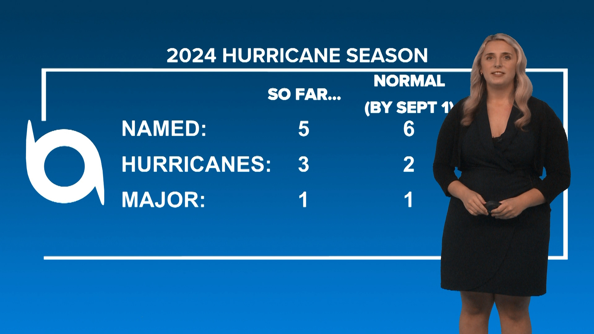
By the numbers, the 2024 season has produced 5 named storms, 3 hurricanes, and 1 major hurricane as of late August. On average, this is about where we should be at this point in the season. But you may remember that if the conditions line up just right like with record-setting Hurricane Beryl, storms can become behemoths in those super-hot Atlantic Ocean waters.
Even though the season has not been extremely busy just yet, it’s very important to not let your guard down, have a plan, and be ready in case a storm is heading our way. As we know, the season doesn’t end until November 30th so there’s a lot of hurricane season left to deal with.
Of course, in Southeast LA and South MS, tropical weather and heat are our biggest things. But if you’re ready for what we call “winter” in the Deep South, the incoming La Nina could play a part in how it’ll look during the upcoming 2024-2025 season.
Typically, in a La Nina year, the Gulf South tends to be drier and warmer than average. The reason behind this is that the jet stream is more variable and can become positioned in the northern part of the United States, keeping the cold and unsettled weather farther north.
There are of course other shorter-term climate interactions like the North Atlantic and Arctic Oscillations that can enhance cold or warm spells and stormy or calm conditions across the country.
So, it’s always important to take any long-range outlooks with a grain of salt since there are so many contributing factors that make up our day-to-day weather.
► Get breaking news from your neighborhood delivered directly to you by downloading the new FREE WWL-TV News app now in the IOS App Store or Google Play.
Video: Muggy weekend with passing storms on Sunday